Staryy Krym geodata
Staryy Krym (Donetsk) is a populated place; located in Ukraine in Europe/Kiev (GMT+3) time zone. With population of 5,977 people, there are 572 cities with bigger population in this country. Compared to other cities in Ukraine, 63.1% of cities are located further ↑North; 92.4% of cities are located further ←West and 79.5% of cities have higher elevation than Staryy Krym. Note1


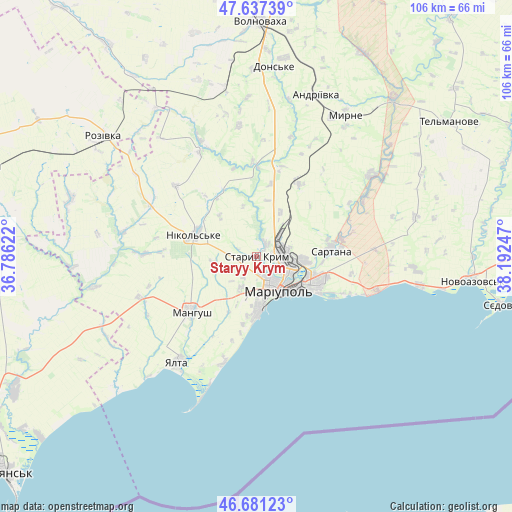
Staryy Krym GPS coordinates[2]
47° 9' 41.256" North, 37° 29' 21.624" East
| Map corner | latitude | longitude |
|---|---|---|
| Upper-left | 47.63739°, | 36.78622° |
| Center: | 47.16146°, | 37.48934° |
| Lower-right: | 46.68123°, | 38.19247° |
| Map W x H: | 106.3×106.3 km | = 66.1×66.1mi |
| max Lat: | 52.18903° ⇑63.1% North |
| Staryy Krym: | 47.16146° |
| min Lat: | ⇓36.9% South 44.39214° |
| min Long | Staryy Krym | max Long |
| 22.20555° | 37.48934° | 40.13222° |
| W 92.4%⇐ | ⇒7.6% E |
Elevation
Elevation of Staryy Krym is 45 m = 148 ft, and this is 110.8 m = 364 ft below average elevation for this country.
| Max E: |
886 m = 2907 ft | 79.5% |
| Avg. | 155.8 m = 511 ft | |
| Staryy Krym | 45 m = 148 ft | |
Min E: |
-3 m = -10 ft | 20.5% |
See also: Ukraine elevation on elevation.city.
Geographical zone
Staryy Krym is located in North temperate zone (between Tropic of Cancer and the Arctic Circle). Distance of this North polar circle is 2157.3 km =1340.5 mi to North.| Distance of | km | miles | from Staryy Krym |
|---|---|---|---|
| North Pole | 4763.2 | 2959.7 | to North |
| Arctic Circle | 2157.3 | 1340.5 | to North |
| Tropic Cancer | 2637.9 | 1639.1 | to South |
| Equator | 5243.9 | 3258.4 | to South |


Nearby cities:
15 places around Staryy Krym: (largest is in red/bold)
• Bezimenne
34.5 km =21.4 mi,  100°
100°
• Dianivka
29.8 km =18.5 mi,  346°
346°
• Kalynove
32.9 km =20.4 mi,  356°
356°
• Manhush
17.9 km =11.1 mi,  229°
229°
• Mariupol
8.4 km =5.2 mi,  151°
151°
• Melekyne
23.5 km =14.6 mi,  196°
196°
• Nikol's’ke
13.6 km =8.5 mi,  291°
291°
• Novoazovs'k
45.4 km =28.2 mi, 96°
• Pikuzy
24.4 km =15.2 mi,  86°
86°
• Rozivka
40.3 km =25 mi,  307°
307°
• Sartana
15.4 km =9.6 mi,  84°
84°
• Temriuk
40.2 km =25 mi, 287°
• Urzuf
40.2 km =25 mi, 227°
• Volnovakha
48.9 km =30.4 mi,  0°
0°
• Yalta
27.5 km =17.1 mi,  216°
216°
Sources, notices
• [Note1] Compared only with cities in Ukraine existing in our database
• [Src1] Map data: © OpenStreetMap contributors (CC-BY-SA)
• [Src2] Other city data from geonames.org with taken over terms of usage.
• [Src3] Geographical zone / Annual Mean Temperature by Robert A. Rohde @ Wikipedia
