Komarovka geodata
Komarovka (Republic of Crimea) is a populated place; located in Ukraine in Europe/Simferopol (GMT+3) time zone. With population of 660 people, there are 1550 cities with bigger population in this country. Compared to other cities in Ukraine, 81.2% of cities are located further ↑North; 66.7% of cities are located further ←West and 72.8% of cities have higher elevation than Komarovka. Note1
Administrative division(s):
- Level 1: Republic of Crimea
- Level 2: Krasnohvardiiske Raion
- Level 3: Poltavskoye sel'skoye poselenye


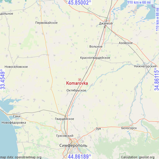
Komarovka GPS coordinates[2]
45° 21' 29.196" North, 34° 9' 28.872" East
| Map corner | latitude | longitude |
|---|---|---|
| Upper-left | 45.85002°, | 33.4549° |
| Center: | 45.35811°, | 34.15802° |
| Lower-right: | 44.86189°, | 34.86115° |
| Map W x H: | 109.9×109.9 km | = 68.3×68.3mi |
| max Lat: | 52.18903° ⇑81.2% North |
| Komarovka: | 45.35811° |
| min Lat: | ⇓18.8% South 44.39214° |
| min Long | Komarovka | max Long |
| 22.20555° | 34.15802° | 40.13222° |
| W 66.7%⇐ | ⇒33.3% E |
Elevation
Elevation of Komarovka is 68 m = 223 ft, and this is 87.8 m = 288 ft below average elevation for this country.
| Max E: |
886 m = 2907 ft | 72.8% |
| Avg. | 155.8 m = 511 ft | |
| Komarovka | 68 m = 223 ft | |
Min E: |
-3 m = -10 ft | 27.2% |
See also: Ukraine elevation on elevation.city.
Geographical zone
Komarovka is located in North temperate zone (between Tropic of Cancer and the Arctic Circle). Distance of this North polar circle is 2357.8 km =1465.1 mi to North.| Distance of | km | miles | from Komarovka |
|---|---|---|---|
| North Pole | 4963.7 | 3084.3 | to North |
| Arctic Circle | 2357.8 | 1465.1 | to North |
| Tropic Cancer | 2437.4 | 1514.5 | to South |
| Equator | 5043.3 | 3133.8 | to South |


Nearby cities:
15 places around Komarovka: (largest is in red/bold)
• Amurskoye
9.2 km =5.7 mi,  194°
194°
• Dubrovskoye
4.5 km =2.8 mi,  324°
324°
• Kotel’nikovo
10.4 km =6.5 mi,  274°
274°
• Krasnaya Polyana
13.1 km =8.1 mi,  349°
349°
• Krasny Partizan
7.1 km =4.4 mi,  44°
44°
• Leninskoye
13.1 km =8.1 mi,  220°
220°
• Mirolyubovka
13.5 km =8.4 mi,  21°
21°
• Nekrasovo
12.4 km =7.7 mi,  53°
53°
• Novoalekseyevka
8.1 km =5 mi,  206°
206°
• Novozuyevka
13.3 km =8.3 mi,  181°
181°
• Oktyabr’skoye
7.9 km =4.9 mi, 193°
• Poltavka
2.1 km =1.3 mi,  110°
110°
• Pyatikhatka
8.5 km =5.3 mi,  116°
116°
• Udachnoye
10.3 km =6.4 mi,  70°
70°
• Yantarnoye
9.8 km =6.1 mi,  30°
30°
Sources, notices
• [Note1] Compared only with cities in Ukraine existing in our database
• [Src1] Map data: © OpenStreetMap contributors (CC-BY-SA)
• [Src2] Other city data from geonames.org with taken over terms of usage.
• [Src3] Geographical zone / Annual Mean Temperature by Robert A. Rohde @ Wikipedia
