Udachnoye geodata
Udachnoye (Republic of Crimea) is a populated place; located in Ukraine in Europe/Simferopol (GMT+3) time zone. With population of 896 people, there are 1435 cities with bigger population in this country. Compared to other cities in Ukraine, 80% of cities are located further ↑North; 69.1% of cities are located further ←West and 75.7% of cities have higher elevation than Udachnoye. Note1
Administrative division(s):
- Level 1: Republic of Crimea
- Level 2: Krasnohvardiiske Raion
- Level 3: Yantarnenskoye sel'skoye poselenye


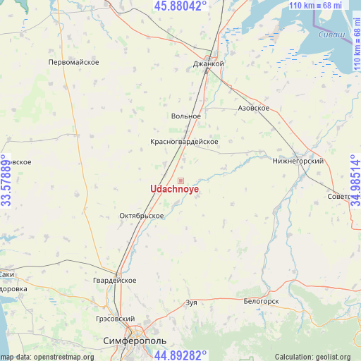
Udachnoye GPS coordinates[2]
45° 23' 19.608" North, 34° 16' 55.236" East
| Map corner | latitude | longitude |
|---|---|---|
| Upper-left | 45.88042°, | 33.57889° |
| Center: | 45.38878°, | 34.28201° |
| Lower-right: | 44.89282°, | 34.98514° |
| Map W x H: | 109.8×109.8 km | = 68.2×68.2mi |
| max Lat: | 52.18903° ⇑80% North |
| Udachnoye: | 45.38878° |
| min Lat: | ⇓20% South 44.39214° |
| min Long | Udachnoye | max Long |
| 22.20555° | 34.28201° | 40.13222° |
| W 69.1%⇐ | ⇒30.9% E |
Elevation
Elevation of Udachnoye is 58 m = 190 ft, and this is 97.8 m = 321 ft below average elevation for this country.
| Max E: |
886 m = 2907 ft | 75.7% |
| Avg. | 155.8 m = 511 ft | |
| Udachnoye | 58 m = 190 ft | |
Min E: |
-3 m = -10 ft | 24.3% |
See also: Ukraine elevation on elevation.city.
Geographical zone
Udachnoye is located in North temperate zone (between Tropic of Cancer and the Arctic Circle). Distance of this North polar circle is 2354.4 km =1463 mi to North.| Distance of | km | miles | from Udachnoye |
|---|---|---|---|
| North Pole | 4960.3 | 3082.2 | to North |
| Arctic Circle | 2354.4 | 1463 | to North |
| Tropic Cancer | 2440.8 | 1516.6 | to South |
| Equator | 5046.8 | 3135.9 | to South |


Nearby cities:
15 places around Udachnoye: (largest is in red/bold)
• Dubrovskoye
12.3 km =7.6 mi,  271°
271°
• Komarovka
10.3 km =6.4 mi,  250°
250°
• Krasnogvardeyskoye
12.8 km =8 mi,  6°
6°
• Krasny Partizan
5 km =3.1 mi,  289°
289°
• Mar’yanovka
6.5 km =4 mi, 8°
• Mirolyubovka
10.2 km =6.3 mi,  332°
332°
• Molochnoye
5.7 km =3.5 mi,  87°
87°
• Nekrasovo
4 km =2.5 mi,  3°
3°
• Novoestoniya
12.7 km =7.9 mi,  346°
346°
• Petrovka
12.1 km =7.5 mi, 2°
• Poltavka
8.7 km =5.4 mi,  241°
241°
• Pyatikhatka
7.6 km =4.7 mi,  196°
196°
• Rovnoye
6.9 km =4.3 mi,  127°
127°
• Shcherbakovo
11.8 km =7.3 mi,  26°
26°
• Yantarnoye
7 km =4.3 mi,  317°
317°
Sources, notices
• [Note1] Compared only with cities in Ukraine existing in our database
• [Src1] Map data: © OpenStreetMap contributors (CC-BY-SA)
• [Src2] Other city data from geonames.org with taken over terms of usage.
• [Src3] Geographical zone / Annual Mean Temperature by Robert A. Rohde @ Wikipedia
