Krinichnaya geodata
Krinichnaya (Donetsk) is a populated place; located in Ukraine in Europe/Kiev (GMT+3) time zone. With population of 4,530 people, there are 698 cities with bigger population in this country. Compared to other cities in Ukraine, 54.1% of cities are located further ↑North; 94.5% of cities are located further ←West and 78.3% of cities have lower elevation than Krinichnaya. Note1


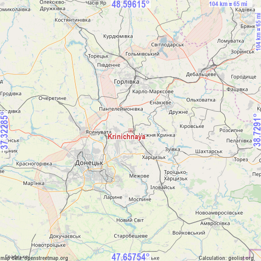
Krinichnaya GPS coordinates[2]
48° 7' 44.364" North, 38° 1' 33.492" East
| Map corner | latitude | longitude |
|---|---|---|
| Upper-left | 48.59615°, | 37.32285° |
| Center: | 48.12899°, | 38.02597° |
| Lower-right: | 47.65754°, | 38.7291° |
| Map W x H: | 104.4×104.4 km | = 64.9×64.9mi |
| max Lat: | 52.18903° ⇑54.1% North |
| Krinichnaya: | 48.12899° |
| min Lat: | ⇓45.9% South 44.39214° |
| min Long | Krinichnaya | max Long |
| 22.20555° | 38.02597° | 40.13222° |
| W 94.5%⇐ | ⇒5.5% E |
Elevation
Elevation of Krinichnaya is 240 m = 787 ft, and this is 84.2 m = 276 ft above average elevation for this country.
| Max E: |
886 m = 2907 ft | 21.7% |
| Krinichnaya | 240 m 787 ft | |
| Avg. | 155.8 m = 511 ft | |
Min E: |
-3 m = -10 ft | 78.3% |
See also: Ukraine elevation on elevation.city.
Geographical zone
Krinichnaya is located in North temperate zone (between Tropic of Cancer and the Arctic Circle). Distance of this North polar circle is 2049.7 km =1273.6 mi to North.| Distance of | km | miles | from Krinichnaya |
|---|---|---|---|
| North Pole | 4655.6 | 2892.9 | to North |
| Arctic Circle | 2049.7 | 1273.6 | to North |
| Tropic Cancer | 2745.5 | 1706 | to South |
| Equator | 5351.4 | 3325.2 | to South |


Nearby cities:
15 places around Krinichnaya: (largest is in red/bold)
• Avdiyivka
21.1 km =13.1 mi,  273°
273°
• Donetsk
20.4 km =12.7 mi,  234°
234°
• Horlivka
23.1 km =14.4 mi,  5°
5°
• Ilovays’k
26.2 km =16.3 mi,  149°
149°
• Khartsyz’k
13.2 km =8.2 mi,  136°
136°
• Krasnyy Oktyabr’
18.6 km =11.6 mi,  43°
43°
• Makiyivka
11.7 km =7.3 mi,  219°
219°
• Nyzhnya Krynka
10.1 km =6.3 mi,  99°
99°
• P'yatypill'ya
13.7 km =8.5 mi,  156°
156°
• Shakhtne
25 km =15.5 mi,  130°
130°
• Shyroke
24.5 km =15.2 mi, 141°
• Vysoke
20.7 km =12.9 mi,  173°
173°
• Yasynuvata
12.4 km =7.7 mi, 270°
• Yenakiyeve
18 km =11.2 mi,  49°
49°
• Zuhres
22 km =13.7 mi, 126°
Sources, notices
• [Note1] Compared only with cities in Ukraine existing in our database
• [Src1] Map data: © OpenStreetMap contributors (CC-BY-SA)
• [Src2] Other city data from geonames.org with taken over terms of usage.
• [Src3] Geographical zone / Annual Mean Temperature by Robert A. Rohde @ Wikipedia
