Yenakiyeve geodata
Yenakiyeve (Donetsk) is a populated place; located in Ukraine in Europe/Kiev (GMT+3) time zone. With population of 104,101 people, there are 44 cities with bigger population in this country. Compared to other cities in Ukraine, 51.5% of cities are located further ↑North; 95.5% of cities are located further ←West and 70.6% of cities have lower elevation than Yenakiyeve. Note1


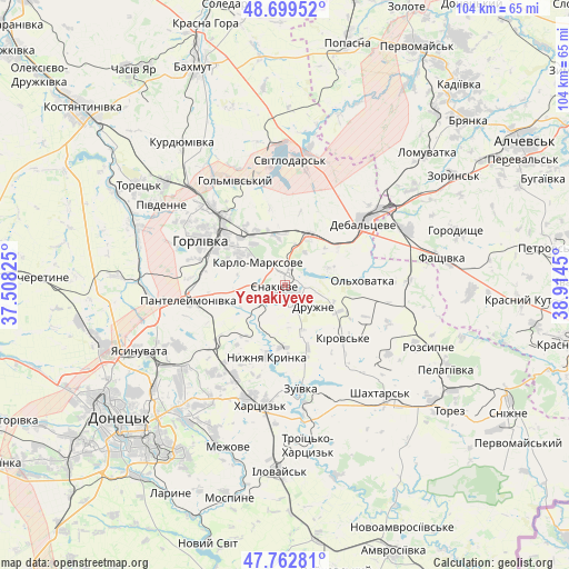
Yenakiyeve GPS coordinates[2]
48° 13' 59.916" North, 38° 12' 40.932" East
| Map corner | latitude | longitude |
|---|---|---|
| Upper-left | 48.69952°, | 37.50825° |
| Center: | 48.23331°, | 38.21137° |
| Lower-right: | 47.76281°, | 38.9145° |
| Map W x H: | 104.2×104.2 km | = 64.7×64.7mi |
| max Lat: | 52.18903° ⇑51.5% North |
| Yenakiyeve: | 48.23331° |
| min Lat: | ⇓48.5% South 44.39214° |
| min Long | Yenakiyeve | max Long |
| 22.20555° | 38.21137° | 40.13222° |
| W 95.5%⇐ | ⇒4.5% E |
Elevation
Elevation of Yenakiyeve is 208 m = 682 ft, and this is 52.2 m = 171 ft above average elevation for this country.
| Max E: |
886 m = 2907 ft | 29.4% |
| Yenakiyeve | 208 m 682 ft | |
| Avg. | 155.8 m = 511 ft | |
Min E: |
-3 m = -10 ft | 70.6% |
See also: Yenakiyeve elevation on elevation.city.
Geographical zone
Yenakiyeve is located in North temperate zone (between Tropic of Cancer and the Arctic Circle). Distance of this North polar circle is 2038.1 km =1266.4 mi to North.| Distance of | km | miles | from Yenakiyeve |
|---|---|---|---|
| North Pole | 4644 | 2885.6 | to North |
| Arctic Circle | 2038.1 | 1266.4 | to North |
| Tropic Cancer | 2757.1 | 1713.2 | to South |
| Equator | 5363 | 3332.4 | to South |


Nearby cities:
15 places around Yenakiyeve: (largest is in red/bold)
• Chornukhyne
25.1 km =15.6 mi,  66°
66°
• Debal’tseve
18.6 km =11.6 mi,  50°
50°
• Horlivka
16.3 km =10.1 mi,  314°
314°
• Khartsyz’k
21.8 km =13.5 mi,  192°
192°
• Krasnyy Oktyabr’
2 km =1.2 mi,  335°
335°
• Krinichnaya
18 km =11.2 mi,  229°
229°
• Luhans’ke
23.9 km =14.9 mi,  8°
8°
• Nyzhnya Krynka
13.8 km =8.6 mi,  195°
195°
• P'yatypill'ya
25.6 km =15.9 mi, 198°
• Shakhtars’k
25.9 km =16.1 mi,  139°
139°
• Shakhtne
28.3 km =17.6 mi,  169°
169°
• Stizhkivs’ke
24.7 km =15.3 mi,  122°
122°
• Svetlodarsk
22.3 km =13.9 mi,  2°
2°
• Vuhlehirs’k
10.2 km =6.3 mi,  27°
27°
• Zuhres
25 km =15.5 mi, 170°
Sources, notices
• [Note1] Compared only with cities in Ukraine existing in our database
• [Src1] Map data: © OpenStreetMap contributors (CC-BY-SA)
• [Src2] Other city data from geonames.org with taken over terms of usage.
• [Src3] Geographical zone / Annual Mean Temperature by Robert A. Rohde @ Wikipedia
