Tatariv geodata
Tatariv (Ivano-Frankivsk) is a populated place; located in Ukraine in Europe/Kiev (GMT+3) time zone. With population of 1,508 people, there are 1209 cities with bigger population in this country. Compared to other cities in Ukraine, 51.3% of cities are located further ↓South; 88.8% of cities are located further →East and 99.5% of cities have lower elevation than Tatariv. Note1


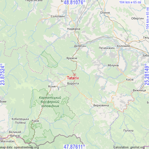
Tatariv GPS coordinates[2]
48° 20' 44.088" North, 24° 34' 42.096" East
| Map corner | latitude | longitude |
|---|---|---|
| Upper-left | 48.81076°, | 23.87524° |
| Center: | 48.34558°, | 24.57836° |
| Lower-right: | 47.87611°, | 25.28149° |
| Map W x H: | 103.9×103.9 km | = 64.6×64.6mi |
| max Lat: | 52.18903° ⇑48.7% North |
| Tatariv: | 48.34558° |
| min Lat: | ⇓51.3% South 44.39214° |
| min Long | Tatariv | max Long |
| 22.20555° | 24.57836° | 40.13222° |
| W 11.2%⇐ | ⇒88.8% E |
Elevation
Elevation of Tatariv is 678 m = 2224 ft, and this is 522.2 m = 1713 ft above average elevation for this country.
| Max E: |
886 m = 2907 ft | 0.5% |
| Tatariv | 678 m 2224 ft | |
| Avg. | 155.8 m = 511 ft | |
Min E: |
-3 m = -10 ft | 99.5% |
See also: Ukraine elevation on elevation.city.
Geographical zone
Tatariv is located in North temperate zone (between Tropic of Cancer and the Arctic Circle). Distance of this North polar circle is 2025.6 km =1258.6 mi to North.| Distance of | km | miles | from Tatariv |
|---|---|---|---|
| North Pole | 4631.5 | 2877.9 | to North |
| Arctic Circle | 2025.6 | 1258.6 | to North |
| Tropic Cancer | 2769.6 | 1720.9 | to South |
| Equator | 5375.5 | 3340.2 | to South |


Nearby cities:
15 places around Tatariv: (largest is in red/bold)
• Bili Oslavy
18.2 km =11.3 mi,  29°
29°
• Delyatyn
20.1 km =12.5 mi,  9°
9°
• Kosmach
18 km =11.2 mi,  95°
95°
• Krasna
27.1 km =16.8 mi,  19°
19°
• Krivopol’ye
18.9 km =11.7 mi,  152°
152°
• Lanchyn
27 km =16.8 mi, 29°
• Lazeshchyna
14.5 km =9 mi,  233°
233°
• Palyanytsya
10.3 km =6.4 mi,  272°
272°
• Rechka
27.2 km =16.9 mi,  105°
105°
• Verkhovyna
26.3 km =16.3 mi,  143°
143°
• Vorokhta
6.8 km =4.2 mi,  188°
188°
• Yablunytsya
7.6 km =4.7 mi,  245°
245°
• Yaremche
11.9 km =7.4 mi,  351°
351°
• Yasinya
17.7 km =11 mi, 245°
• Zarichchya
20.2 km =12.6 mi, 14°
Sources, notices
• [Note1] Compared only with cities in Ukraine existing in our database
• [Src1] Map data: © OpenStreetMap contributors (CC-BY-SA)
• [Src2] Other city data from geonames.org with taken over terms of usage.
• [Src3] Geographical zone / Annual Mean Temperature by Robert A. Rohde @ Wikipedia
