Krasnosel’skoye geodata
Krasnosel’skoye (Republic of Crimea) is a populated place; located in Ukraine in Europe/Simferopol (GMT+3) time zone. With population of 505 people, there are 1654 cities with bigger population in this country. Compared to other cities in Ukraine, 79.2% of cities are located further ↑North; 54.3% of cities are located further →East and 62.4% of cities have higher elevation than Krasnosel’skoye. Note1
Administrative division(s):
- Level 1: Republic of Crimea
- Level 2: Chernomorskiy rayon
- Level 3: Okunevskoye sel'skoye poselenye


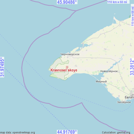
Krasnosel’skoye GPS coordinates[2]
45° 24' 48.348" North, 32° 40' 41.052" East
| Map corner | latitude | longitude |
|---|---|---|
| Upper-left | 45.90486°, | 31.97495° |
| Center: | 45.41343°, | 32.67807° |
| Lower-right: | 44.91769°, | 33.3812° |
| Map W x H: | 109.8×109.8 km | = 68.2×68.2mi |
| max Lat: | 52.18903° ⇑79.2% North |
| Krasnosel’skoye: | 45.41343° |
| min Lat: | ⇓20.8% South 44.39214° |
| min Long | Krasnosel’sko | max Long |
| 22.20555° | 32.67807° | 40.13222° |
| W 45.7%⇐ | ⇒54.3% E |
Elevation
Elevation of Krasnosel’skoye is 99 m = 325 ft, and this is 56.8 m = 186 ft below average elevation for this country.
| Max E: |
886 m = 2907 ft | 62.4% |
| Avg. | 155.8 m = 511 ft | |
| Krasnosel’skoye | 99 m = 325 ft | |
Min E: |
-3 m = -10 ft | 37.6% |
See also: Ukraine elevation on elevation.city.
Geographical zone
Krasnosel’skoye is located in North temperate zone (between Tropic of Cancer and the Arctic Circle). Distance of this North polar circle is 2351.7 km =1461.3 mi to North.| Distance of | km | miles | from Krasnosel’skoye |
|---|---|---|---|
| North Pole | 4957.6 | 3080.5 | to North |
| Arctic Circle | 2351.7 | 1461.3 | to North |
| Tropic Cancer | 2443.6 | 1518.4 | to South |
| Equator | 5049.5 | 3137.6 | to South |


Nearby cities:
15 places around Krasnosel’skoye: (largest is in red/bold)
• Chernomorskoye
10.5 km =6.5 mi,  8°
8°
• Dalekoye
41.7 km =25.9 mi,  48°
48°
• Kalinovka
8 km =5 mi,  4°
4°
• Kirovskoye
34.4 km =21.4 mi,  64°
64°
• Krasnaya Polyana
21.7 km =13.5 mi,  69°
69°
• Medvedevo
25.6 km =15.9 mi,  96°
96°
• Mezhvodnoye
23.3 km =14.5 mi,  33°
33°
• Mirny
30.3 km =18.8 mi,  112°
112°
• Novoivanovka
33 km =20.5 mi,  83°
83°
• Novoozyornoye
34.4 km =21.4 mi, 95°
• Novosel’skoye
10.6 km =6.6 mi,  19°
19°
• Okunevka
8.3 km =5.2 mi,  126°
126°
• Olenevka
11.8 km =7.3 mi,  253°
253°
• Shtormovoye
35.9 km =22.3 mi,  116°
116°
• Veselovka
42 km =26.1 mi, 95°
Sources, notices
• [Note1] Compared only with cities in Ukraine existing in our database
• [Src1] Map data: © OpenStreetMap contributors (CC-BY-SA)
• [Src2] Other city data from geonames.org with taken over terms of usage.
• [Src3] Geographical zone / Annual Mean Temperature by Robert A. Rohde @ Wikipedia
