Dalekoye geodata
Dalekoye (Republic of Crimea) is a seat of a third-order administrative division; located in Ukraine in Europe/Simferopol (GMT+3) time zone. With population of 782 people, there are 1497 cities with bigger population in this country. Compared to other cities in Ukraine, 74.2% of cities are located further ↑North; 52.2% of cities are located further →East and 82.5% of cities have higher elevation than Dalekoye. Note1
Administrative division(s):
- Level 1: Republic of Crimea
- Level 2: Chernomorskiy rayon
- Level 3: Dalekovskoye sel'skoye poselenye


Dalekoye GPS coordinates[2]
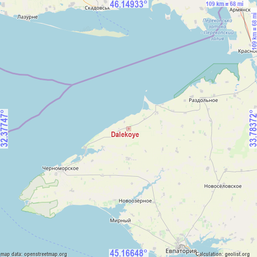
45° 39' 36.216" North, 33° 4' 50.124" East
| Map corner | latitude | longitude |
|---|---|---|
| Upper-left | 46.14933°, | 32.37747° |
| Center: | 45.66006°, | 33.08059° |
| Lower-right: | 45.16648°, | 33.78372° |
| Map W x H: | 109.3×109.3 km | = 67.9×67.9mi |
| max Lat: | 52.18903° ⇑74.2% North |
| Dalekoye: | 45.66006° |
| min Lat: | ⇓25.8% South 44.39214° |
| min Long | Dalekoye | max Long |
| 22.20555° | 33.08059° | 40.13222° |
| W 47.8%⇐ | ⇒52.2% E |
Elevation
Elevation of Dalekoye is 37 m = 121 ft, and this is 118.8 m = 390 ft below average elevation for this country.
| Max E: |
886 m = 2907 ft | 82.5% |
| Avg. | 155.8 m = 511 ft | |
| Dalekoye | 37 m = 121 ft | |
Min E: |
-3 m = -10 ft | 17.5% |
See also: Ukraine elevation on elevation.city.
Geographical zone
Dalekoye is located in North temperate zone (between Tropic of Cancer and the Arctic Circle). Distance of this North polar circle is 2324.3 km =1444.3 mi to North.| Distance of | km | miles | from Dalekoye |
|---|---|---|---|
| North Pole | 4930.1 | 3063.4 | to North |
| Arctic Circle | 2324.3 | 1444.3 | to North |
| Tropic Cancer | 2471 | 1535.4 | to South |
| Equator | 5076.9 | 3154.6 | to South |


Nearby cities:
15 places around Dalekoye: (largest is in red/bold)
• Berezovka
22.6 km =14 mi,  114°
114°
• Chernyshevo
30.2 km =18.8 mi,  63°
63°
• Kirovskoye
12.8 km =8 mi,  181°
181°
• Krasnaya Polyana
22.7 km =14.1 mi,  209°
209°
• Krasnoyarskoye
22.4 km =13.9 mi,  139°
139°
• Kukushkino
24.9 km =15.5 mi,  74°
74°
• Medvedevo
31.1 km =19.3 mi,  191°
191°
• Mezhvodnoye
20 km =12.4 mi,  246°
246°
• Niva
16.9 km =10.5 mi,  121°
121°
• Novoivanovka
23.5 km =14.6 mi, 176°
• Novoozyornoye
30.9 km =19.2 mi,  174°
174°
• Ogni
26.7 km =16.6 mi, 63°
• Orlovka
22.8 km =14.2 mi,  87°
87°
• Slavnoye
13.9 km =8.6 mi, 60°
• Slavyanskoye
20.2 km =12.6 mi, 68°
Sources, notices
• [Note1] Compared only with cities in Ukraine existing in our database
• [Src1] Map data: © OpenStreetMap contributors (CC-BY-SA)
• [Src2] Other city data from geonames.org with taken over terms of usage.
• [Src3] Geographical zone / Annual Mean Temperature by Robert A. Rohde @ Wikipedia
