Kyrylivka geodata
Kyrylivka (Zaporizhia) is a populated place; located in Ukraine in Europe/Zaporozhye (GMT+3) time zone. With population of 1,422 people, there are 1234 cities with bigger population in this country. Compared to other cities in Ukraine, 67.5% of cities are located further ↑North; 83.9% of cities are located further ←West and 95.8% of cities have higher elevation than Kyrylivka. Note1


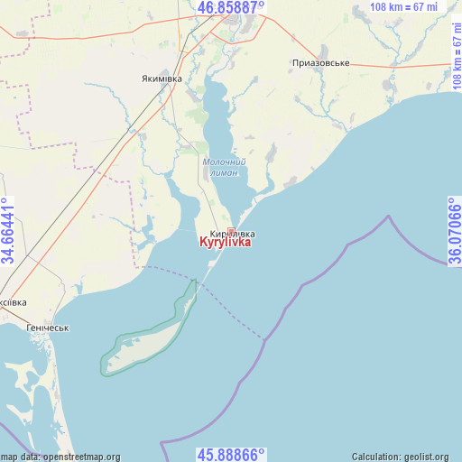
Kyrylivka GPS coordinates[2]
46° 22' 33.312" North, 35° 22' 3.108" East
| Map corner | latitude | longitude |
|---|---|---|
| Upper-left | 46.85887°, | 34.66441° |
| Center: | 46.37592°, | 35.36753° |
| Lower-right: | 45.88866°, | 36.07066° |
| Map W x H: | 107.9×107.9 km | = 67×67mi |
| max Lat: | 52.18903° ⇑67.5% North |
| Kyrylivka: | 46.37592° |
| min Lat: | ⇓32.5% South 44.39214° |
| min Long | Kyrylivka | max Long |
| 22.20555° | 35.36753° | 40.13222° |
| W 83.9%⇐ | ⇒16.1% E |
Elevation
Elevation of Kyrylivka is 10 m = 33 ft, and this is 145.8 m = 478 ft below average elevation for this country.
| Max E: |
886 m = 2907 ft | 95.8% |
| Avg. | 155.8 m = 511 ft | |
| Kyrylivka | 10 m = 33 ft | |
Min E: |
-3 m = -10 ft | 4.2% |
See also: Ukraine elevation on elevation.city.
Geographical zone
Kyrylivka is located in North temperate zone (between Tropic of Cancer and the Arctic Circle). Distance of this North polar circle is 2244.7 km =1394.8 mi to North.| Distance of | km | miles | from Kyrylivka |
|---|---|---|---|
| North Pole | 4850.5 | 3014 | to North |
| Arctic Circle | 2244.7 | 1394.8 | to North |
| Tropic Cancer | 2550.6 | 1584.9 | to South |
| Equator | 5156.5 | 3204.1 | to South |


Nearby cities:
15 places around Kyrylivka: (largest is in red/bold)
• Heniches’k
48.7 km =30.3 mi,  242°
242°
• Ivanivka
73.1 km =45.4 mi,  301°
301°
• Kostyantynivka
49.2 km =30.6 mi,  4°
4°
• Melitopol
52.6 km =32.7 mi,  359°
359°
• Novobohdanivka
78.9 km =49 mi, 357°
• Novooleksiyivka
58.3 km =36.2 mi,  253°
253°
• Novotroyits’ke
79.4 km =49.3 mi,  268°
268°
• Novovasylivka
58.4 km =36.3 mi,  30°
30°
• Partyzany
47.4 km =29.5 mi,  264°
264°
• Pryazovs’ke
45.1 km =28 mi, 27°
• Rozivka
69.8 km =43.4 mi, 26°
• Terpinnya
66.1 km =41.1 mi, 3°
• Vesele
79 km =49.1 mi,  334°
334°
• Voznesenka
55.6 km =34.5 mi,  7°
7°
• Yakymivka
39.4 km =24.5 mi,  336°
336°
Sources, notices
• [Note1] Compared only with cities in Ukraine existing in our database
• [Src1] Map data: © OpenStreetMap contributors (CC-BY-SA)
• [Src2] Other city data from geonames.org with taken over terms of usage.
• [Src3] Geographical zone / Annual Mean Temperature by Robert A. Rohde @ Wikipedia
