Yakymivka geodata
Yakymivka (Zaporizhia) is a seat of a second-order administrative division; located in Ukraine in Europe/Zaporozhye (GMT+3) time zone. With population of 12,353 people, there are 303 cities with bigger population in this country. Compared to other cities in Ukraine, 65.9% of cities are located further ↑North; 82.1% of cities are located further ←West and 90.1% of cities have higher elevation than Yakymivka. Note1


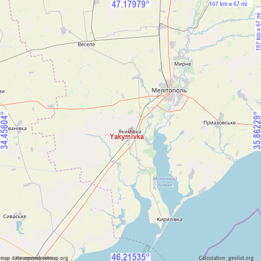
Yakymivka GPS coordinates[2]
46° 41' 58.992" North, 35° 9' 32.976" East
| Map corner | latitude | longitude |
|---|---|---|
| Upper-left | 47.17979°, | 34.45604° |
| Center: | 46.69972°, | 35.15916° |
| Lower-right: | 46.21535°, | 35.86229° |
| Map W x H: | 107.2×107.2 km | = 66.6×66.6mi |
| max Lat: | 52.18903° ⇑65.9% North |
| Yakymivka: | 46.69972° |
| min Lat: | ⇓34.1% South 44.39214° |
| min Long | Yakymivka | max Long |
| 22.20555° | 35.15916° | 40.13222° |
| W 82.1%⇐ | ⇒17.9% E |
Elevation
Elevation of Yakymivka is 19 m = 62 ft, and this is 136.8 m = 449 ft below average elevation for this country.
| Max E: |
886 m = 2907 ft | 90.1% |
| Avg. | 155.8 m = 511 ft | |
| Yakymivka | 19 m = 62 ft | |
Min E: |
-3 m = -10 ft | 9.9% |
See also: Ukraine elevation on elevation.city.
Geographical zone
Yakymivka is located in North temperate zone (between Tropic of Cancer and the Arctic Circle). Distance of this North polar circle is 2208.7 km =1372.4 mi to North.| Distance of | km | miles | from Yakymivka |
|---|---|---|---|
| North Pole | 4814.5 | 2991.6 | to North |
| Arctic Circle | 2208.7 | 1372.4 | to North |
| Tropic Cancer | 2586.6 | 1607.2 | to South |
| Equator | 5192.5 | 3226.5 | to South |


Nearby cities:
15 places around Yakymivka: (largest is in red/bold)
• Ivanivka
46.3 km =28.8 mi,  272°
272°
• Kostyantynivka
23.9 km =14.9 mi,  57°
57°
• Kyrylivka
39.4 km =24.5 mi,  156°
156°
• Matviyivka
41.7 km =25.9 mi,  358°
358°
• Melitopol
22.8 km =14.2 mi,  43°
43°
• Novobohdanivka
44.8 km =27.8 mi,  16°
16°
• Novovasylivka
47.4 km =29.5 mi,  72°
72°
• Nyzhni Sirohozy
61.6 km =38.3 mi,  285°
285°
• Partyzany
51.2 km =31.8 mi,  217°
217°
• Pryazovs’ke
37 km =23 mi,  84°
84°
• Rozivka
53.7 km =33.4 mi, 60°
• Terpinnya
36 km =22.4 mi,  33°
33°
• Tymoshivka
54 km =33.6 mi, 356°
• Vesele
39.6 km =24.6 mi,  332°
332°
• Voznesenka
30.1 km =18.7 mi,  50°
50°
Sources, notices
• [Note1] Compared only with cities in Ukraine existing in our database
• [Src1] Map data: © OpenStreetMap contributors (CC-BY-SA)
• [Src2] Other city data from geonames.org with taken over terms of usage.
• [Src3] Geographical zone / Annual Mean Temperature by Robert A. Rohde @ Wikipedia
