Vvedenka geodata
Vvedenka (Kharkiv) is a populated place; located in Ukraine in Europe/Kiev (GMT+3) time zone. With population of 2,628 people, there are 1009 cities with bigger population in this country. Compared to other cities in Ukraine, 80% of cities are located further ↓South; 89.7% of cities are located further ←West and 63% of cities have higher elevation than Vvedenka. Note1


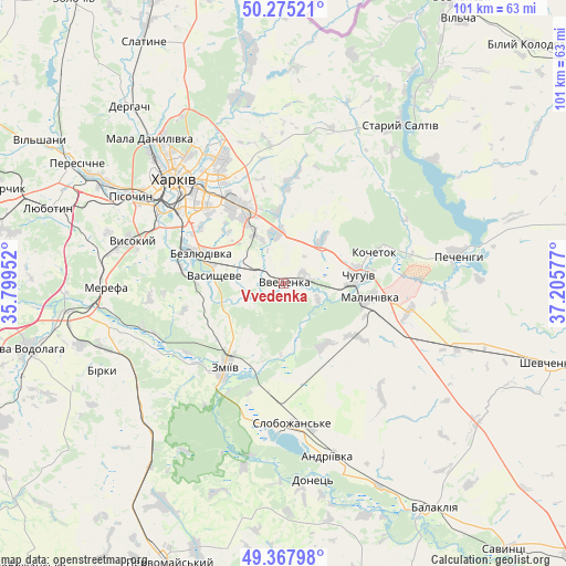
Vvedenka GPS coordinates[2]
49° 49' 25.392" North, 36° 30' 9.504" East
| Map corner | latitude | longitude |
|---|---|---|
| Upper-left | 50.27521°, | 35.79952° |
| Center: | 49.82372°, | 36.50264° |
| Lower-right: | 49.36798°, | 37.20577° |
| Map W x H: | 100.9×100.9 km | = 62.7×62.7mi |
| max Lat: | 52.18903° ⇑20% North |
| Vvedenka: | 49.82372° |
| min Lat: | ⇓80% South 44.39214° |
| min Long | Vvedenka | max Long |
| 22.20555° | 36.50264° | 40.13222° |
| W 89.7%⇐ | ⇒10.3% E |
Elevation
Elevation of Vvedenka is 97 m = 318 ft, and this is 58.8 m = 193 ft below average elevation for this country.
| Max E: |
886 m = 2907 ft | 63% |
| Avg. | 155.8 m = 511 ft | |
| Vvedenka | 97 m = 318 ft | |
Min E: |
-3 m = -10 ft | 37% |
See also: Ukraine elevation on elevation.city.
Geographical zone
Vvedenka is located in North temperate zone (between Tropic of Cancer and the Arctic Circle). Distance of this North polar circle is 1861.3 km =1156.6 mi to North.| Distance of | km | miles | from Vvedenka |
|---|---|---|---|
| North Pole | 4467.2 | 2775.8 | to North |
| Arctic Circle | 1861.3 | 1156.6 | to North |
| Tropic Cancer | 2934 | 1823.1 | to South |
| Equator | 5539.9 | 3442.3 | to South |


Nearby cities:
15 places around Vvedenka: (largest is in red/bold)
• Bezlyudivka
18 km =11.2 mi,  288°
288°
• Chuhuyiv
13.4 km =8.3 mi,  84°
84°
• Eskhar
7 km =4.3 mi,  115°
115°
• Kharkiv
25 km =15.5 mi,  314°
314°
• Khorosheve
20.8 km =12.9 mi,  279°
279°
• Kochetok
17.9 km =11.1 mi,  69°
69°
• Kulynychi
19.6 km =12.2 mi,  333°
333°
• Lyman
25.2 km =15.7 mi,  185°
185°
• Malynivka
16.6 km =10.3 mi,  92°
92°
• Novopokrovka
3.4 km =2.1 mi, 71°
• Pokotylivka
25.5 km =15.8 mi, 293°
• Slobozhans’ke
25.3 km =15.7 mi,  176°
176°
• Vasyshcheve
12.6 km =7.8 mi,  272°
272°
• Vysokyy
28.3 km =17.6 mi, 285°
• Zmiyiv
20 km =12.4 mi,  213°
213°
Sources, notices
• [Note1] Compared only with cities in Ukraine existing in our database
• [Src1] Map data: © OpenStreetMap contributors (CC-BY-SA)
• [Src2] Other city data from geonames.org with taken over terms of usage.
• [Src3] Geographical zone / Annual Mean Temperature by Robert A. Rohde @ Wikipedia
