Zmiyiv geodata
Zmiyiv (Kharkiv) is a seat of a second-order administrative division; located in Ukraine in Europe/Kiev (GMT+3) time zone. With population of 16,095 people, there are 242 cities with bigger population in this country. Compared to other cities in Ukraine, 77.6% of cities are located further ↓South; 89.1% of cities are located further ←West and 64.3% of cities have higher elevation than Zmiyiv. Note1


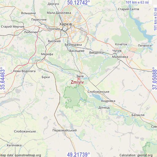
Zmiyiv GPS coordinates[2]
49° 40' 28.308" North, 36° 20' 51.9" East
| Map corner | latitude | longitude |
|---|---|---|
| Upper-left | 50.12742°, | 35.64463° |
| Center: | 49.67453°, | 36.34775° |
| Lower-right: | 49.21739°, | 37.05088° |
| Map W x H: | 101.2×101.2 km | = 62.9×62.9mi |
| max Lat: | 52.18903° ⇑22.4% North |
| Zmiyiv: | 49.67453° |
| min Lat: | ⇓77.6% South 44.39214° |
| min Long | Zmiyiv | max Long |
| 22.20555° | 36.34775° | 40.13222° |
| W 89.1%⇐ | ⇒10.9% E |
Elevation
Elevation of Zmiyiv is 93 m = 305 ft, and this is 62.8 m = 206 ft below average elevation for this country.
| Max E: |
886 m = 2907 ft | 64.3% |
| Avg. | 155.8 m = 511 ft | |
| Zmiyiv | 93 m = 305 ft | |
Min E: |
-3 m = -10 ft | 35.7% |
See also: Ukraine elevation on elevation.city.
Geographical zone
Zmiyiv is located in North temperate zone (between Tropic of Cancer and the Arctic Circle). Distance of this North polar circle is 1877.9 km =1166.9 mi to North.| Distance of | km | miles | from Zmiyiv |
|---|---|---|---|
| North Pole | 4483.8 | 2786.1 | to North |
| Arctic Circle | 1877.9 | 1166.9 | to North |
| Tropic Cancer | 2917.4 | 1812.8 | to South |
| Equator | 5523.3 | 3432 | to South |


Nearby cities:
15 places around Zmiyiv: (largest is in red/bold)
• Bezlyudivka
23.1 km =14.4 mi,  345°
345°
• Chuhuyiv
30.3 km =18.8 mi,  53°
53°
• Eskhar
22.1 km =13.7 mi, 52°
• Khorosheve
22.1 km =13.7 mi,  334°
334°
• Lyman
12.3 km =7.6 mi,  134°
134°
• Malynivka
31.9 km =19.8 mi,  60°
60°
• Merefa
27 km =16.8 mi,  307°
307°
• Novopokrovka
22.8 km =14.2 mi,  39°
39°
• Pivdenne
30.7 km =19.1 mi,  319°
319°
• Pokotylivka
29.3 km =18.2 mi, 334°
• Slobozhans’ke
15.5 km =9.6 mi,  123°
123°
• Utkivka
23.2 km =14.4 mi,  302°
302°
• Vasyshcheve
17.2 km =10.7 mi,  355°
355°
• Vvedenka
20 km =12.4 mi,  33°
33°
• Vysokyy
29.1 km =18.1 mi, 326°
Sources, notices
• [Note1] Compared only with cities in Ukraine existing in our database
• [Src1] Map data: © OpenStreetMap contributors (CC-BY-SA)
• [Src2] Other city data from geonames.org with taken over terms of usage.
• [Src3] Geographical zone / Annual Mean Temperature by Robert A. Rohde @ Wikipedia
