Njeru geodata
Njeru (Central Region) is a populated place; located in Uganda in Africa/Kampala (GMT+3) time zone. With population of 61,952 people, there are 11 cities with bigger population in this country. Compared to other cities in Uganda, 63.7% of cities are located further ↑North; 69.2% of cities are located further ←West and 57.5% of cities have higher elevation than Njeru. Note1
Administrative division(s):
- Level 1: Central Region
- Level 2: Buikwe District
- Level 3: Buikwe
- Level 4: Njeru Town Council


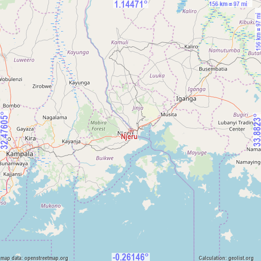
Njeru GPS coordinates[2]
0° 26' 29.976" North, 33° 10' 45.012" East
| Map corner | latitude | longitude |
|---|---|---|
| Upper-left | 1.14471°, | 32.47605° |
| Center: | 0.44166°, | 33.17917° |
| Lower-right: | -0.26146°, | 33.8823° |
| Map W x H: | 156.4×156.4 km | = 97.2×97.2mi |
| max Lat: | 3.66088° ⇑63.7% North |
| Njeru: | 0.44166° |
| min Lat: | ⇓36.3% South -1.28538° |
| min Long | Njeru | max Long |
| 29.65° | 33.17917° | 34.95° |
| W 69.2%⇐ | ⇒30.8% E |
Elevation
Elevation of Njeru is 1152 m = 3780 ft, and this is 107 m = 351 ft below average elevation for this country.
| Max E: |
4129 m = 13547 ft | 57.5% |
| Avg. | 1259 m = 4131 ft | |
| Njeru | 1152 m = 3780 ft | |
Min E: |
622 m = 2041 ft | 42.5% |
See also: Njeru elevation on elevation.city.
Geographical zone
Njeru is located in North Torrid zone (between Equator and Tropic of Cancer). Distance of Equator is 49.1 km =30.5 mi to South.| Distance of | km | miles | from Njeru |
|---|---|---|---|
| North Pole | 9958 | 6187.6 | to North |
| Arctic Circle | 7352.1 | 4568.4 | to North |
| Tropic Cancer | 2556.8 | 1588.7 | to North |
| Equator | 49.1 | 30.5 | to South |


Nearby cities:
15 places around Njeru: (largest is in red/bold)
• Bugembe
8.2 km =5.1 mi,  56°
56°
• Buikwe
22 km =13.7 mi,  238°
238°
• Buwenge
23.2 km =14.4 mi,  357°
357°
• Bweyogerere
58.1 km =36.1 mi,  260°
260°
• Iganga
37.2 km =23.1 mi, 59°
• Jinja
2.7 km =1.7 mi,  96°
96°
• Kaliro
61.7 km =38.3 mi,  35°
35°
• Kamuli
56.6 km =35.2 mi,  353°
353°
• Kayunga
43.4 km =27 mi,  311°
311°
• Kireka
59.9 km =37.2 mi, 259°
• Kitamilo
24.6 km =15.3 mi,  173°
173°
• Lugazi
28.1 km =17.5 mi,  253°
253°
• Luuka Town
31.8 km =19.8 mi,  25°
25°
• Mayuge
33.5 km =20.8 mi,  86°
86°
• Mukono
48.1 km =29.9 mi, 258°
Sources, notices
• [Note1] Compared only with cities in Uganda existing in our database
• [Src1] Map data: © OpenStreetMap contributors (CC-BY-SA)
• [Src2] Other city data from geonames.org with taken over terms of usage.
• [Src3] Geographical zone / Annual Mean Temperature by Robert A. Rohde @ Wikipedia
