Luuka Town geodata
Luuka Town (Eastern Region) is a seat of a second-order administrative division; located in Uganda in Africa/Kampala (GMT+3) time zone. In our database, there are 80 cities with bigger population. Compared to other cities in Uganda, 53.4% of cities are located further ↑North; 73.3% of cities are located further ←West and 58.9% of cities have higher elevation than Luuka Town. Note1
Administrative division(s):
- Level 1: Eastern Region
- Level 2: Luuka District
- Level 3: Luuka County
- Level 4: Nawampiti


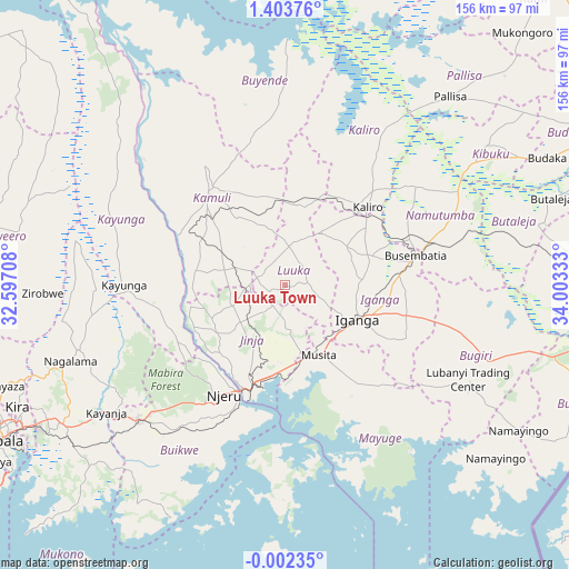
Luuka Town GPS coordinates[2]
0° 42' 2.736" North, 33° 18' 0.72" East
| Map corner | latitude | longitude |
|---|---|---|
| Upper-left | 1.40376°, | 32.59708° |
| Center: | 0.70076°, | 33.3002° |
| Lower-right: | -0.00235°, | 34.00333° |
| Map W x H: | 156.3×156.3 km | = 97.1×97.1mi |
| max Lat: | 3.66088° ⇑53.4% North |
| Luuka Town: | 0.70076° |
| min Lat: | ⇓46.6% South -1.28538° |
| min Long | Luuka Town | max Long |
| 29.65° | 33.3002° | 34.95° |
| W 73.3%⇐ | ⇒26.7% E |
Elevation
Elevation of Luuka Town is 1151 m = 3776 ft, and this is 108 m = 354 ft below average elevation for this country.
| Max E: |
4129 m = 13547 ft | 58.9% |
| Avg. | 1259 m = 4131 ft | |
| Luuka Town | 1151 m = 3776 ft | |
Min E: |
622 m = 2041 ft | 41.1% |
See also: Uganda elevation on elevation.city.
Geographical zone
Luuka Town is located in North Torrid zone (between Equator and Tropic of Cancer). Distance of Equator is 77.9 km =48.4 mi to South.| Distance of | km | miles | from Luuka Town |
|---|---|---|---|
| North Pole | 9929.1 | 6169.7 | to North |
| Arctic Circle | 7323.3 | 4550.5 | to North |
| Tropic Cancer | 2528 | 1570.8 | to North |
| Equator | 77.9 | 48.4 | to South |


Nearby cities:
15 places around Luuka Town: (largest is in red/bold)
• Bugembe
25.2 km =15.7 mi,  195°
195°
• Bugiri
51.1 km =31.8 mi,  106°
106°
• Buikwe
51.7 km =32.1 mi,  218°
218°
• Busembatia
37 km =23 mi,  76°
76°
• Buwenge
15.4 km =9.6 mi,  248°
248°
• Buyende
52.7 km =32.7 mi,  342°
342°
• Iganga
21.3 km =13.2 mi,  118°
118°
• Jinja
31 km =19.3 mi, 200°
• Kaliro
30.9 km =19.2 mi,  45°
45°
• Kamuli
34 km =21.1 mi,  323°
323°
• Kayunga
45.8 km =28.5 mi,  270°
270°
• Kitamilo
54.2 km =33.7 mi,  191°
191°
• Mayuge
33.5 km =20.8 mi,  143°
143°
• Namutumba
45.5 km =28.3 mi,  70°
70°
• Njeru
31.8 km =19.8 mi,  205°
205°
Sources, notices
• [Note1] Compared only with cities in Uganda existing in our database
• [Src1] Map data: © OpenStreetMap contributors (CC-BY-SA)
• [Src2] Other city data from geonames.org with taken over terms of usage.
• [Src3] Geographical zone / Annual Mean Temperature by Robert A. Rohde @ Wikipedia
