Kayunga geodata
Kayunga (Central Region) is a seat of a second-order administrative division; located in Uganda in Africa/Kampala (GMT+3) time zone. With population of 21,704 people, there are 35 cities with bigger population in this country. Compared to other cities in Uganda, 52.7% of cities are located further ↑North; 62.3% of cities are located further ←West and 84.9% of cities have higher elevation than Kayunga. Note1
Administrative division(s):
- Level 1: Central Region
- Level 2: Kayunga District
- Level 3: Ntenjeru County
- Level 4: Kayunga Town Council


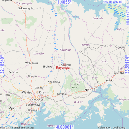
Kayunga GPS coordinates[2]
0° 42' 9" North, 32° 53' 18.996" East
| Map corner | latitude | longitude |
|---|---|---|
| Upper-left | 1.4055°, | 32.18549° |
| Center: | 0.7025°, | 32.88861° |
| Lower-right: | -0.00061°, | 33.59174° |
| Map W x H: | 156.3×156.3 km | = 97.1×97.1mi |
| max Lat: | 3.66088° ⇑52.7% North |
| Kayunga: | 0.7025° |
| min Lat: | ⇓47.3% South -1.28538° |
| min Long | Kayunga | max Long |
| 29.65° | 32.88861° | 34.95° |
| W 62.3%⇐ | ⇒37.7% E |
Elevation
Elevation of Kayunga is 1071 m = 3514 ft, and this is 188 m = 617 ft below average elevation for this country.
| Max E: |
4129 m = 13547 ft | 84.9% |
| Avg. | 1259 m = 4131 ft | |
| Kayunga | 1071 m = 3514 ft | |
Min E: |
622 m = 2041 ft | 15.1% |
See also: Uganda elevation on elevation.city.
Geographical zone
Kayunga is located in North Torrid zone (between Equator and Tropic of Cancer). Distance of Equator is 78.1 km =48.5 mi to South.| Distance of | km | miles | from Kayunga |
|---|---|---|---|
| North Pole | 9929 | 6169.6 | to North |
| Arctic Circle | 7323.1 | 4550.4 | to North |
| Tropic Cancer | 2527.8 | 1570.7 | to North |
| Equator | 78.1 | 48.5 | to South |


Nearby cities:
15 places around Kayunga: (largest is in red/bold)
• Bugembe
46.2 km =28.7 mi,  122°
122°
• Buikwe
42.8 km =26.6 mi,  161°
161°
• Buwenge
32 km =19.9 mi,  100°
100°
• Bweyogerere
45.8 km =28.5 mi,  213°
213°
• Gombe
51.4 km =31.9 mi,  242°
242°
• Jinja
45.6 km =28.3 mi,  129°
129°
• Kamuli
37.4 km =23.2 mi,  43°
43°
• Kireka
47.6 km =29.6 mi, 213°
• Lugazi
37.6 km =23.4 mi,  171°
171°
• Luuka Town
45.8 km =28.5 mi,  90°
90°
• Luwero
49 km =30.4 mi,  289°
289°
• Mukono
41.6 km =25.8 mi,  200°
200°
• Namasuba
52 km =32.3 mi,  268°
268°
• Njeru
43.4 km =27 mi, 131°
• Wobulenzi
41.9 km =26 mi, 273°
Sources, notices
• [Note1] Compared only with cities in Uganda existing in our database
• [Src1] Map data: © OpenStreetMap contributors (CC-BY-SA)
• [Src2] Other city data from geonames.org with taken over terms of usage.
• [Src3] Geographical zone / Annual Mean Temperature by Robert A. Rohde @ Wikipedia
