Edna geodata
Edna (Texas) is a seat of a second-order administrative division; located in United States in America/Chicago (GMT-5) time zone. With population of 5,792 people, there are 6548 cities with bigger population in this country. Compared to other cities in United States, 95.3% of cities are located further ↑North; 74.8% of cities are located further →East and 86.6% of cities have higher elevation than Edna. Note1


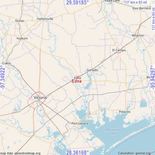
Edna GPS coordinates[2]
28° 58' 42.924" North, 96° 38' 45.924" West
| Map corner | latitude | longitude |
|---|---|---|
| Upper-left | 29.59185°, | -97.34922° |
| Center: | 28.97859°, | -96.64609° |
| Lower-right: | 28.36168°, | -95.94297° |
| Map W x H: | 136.8×136.8 km | = 85×85mi |
| max Lat: | 71.29058° ⇑95.3% North |
| Edna: | 28.97859° |
| min Lat: | ⇓4.7% South 19.06759° |
| min Long | Edna | max Long |
| -171.73463° | -96.64609° | -66.98998° |
| W 25.2%⇐ | ⇒74.8% E |
Elevation
Elevation of Edna is 24 m = 79 ft, and this is 270.8 m = 888 ft below average elevation for this country.
| Max E: |
3189 m = 10463 ft | 86.6% |
| Avg. | 294.8 m = 967 ft | |
| Edna | 24 m = 79 ft | |
Min E: |
-60 m = -197 ft | 13.4% |
See also: United States elevation on elevation.city.
Geographical zone
Edna is located in North temperate zone (between Tropic of Cancer and the Arctic Circle). Distance of this Northern Tropic circle is 616.2 km =382.9 mi to South.| Distance of | km | miles | from Edna |
|---|---|---|---|
| North Pole | 6784.9 | 4215.9 | to North |
| Arctic Circle | 4179.1 | 2596.8 | to North |
| Tropic Cancer | 616.2 | 382.9 | to South |
| Equator | 3222.1 | 2002.1 | to South |


Nearby cities:
15 places around Edna: (largest is in red/bold)
• Blessing
43.3 km =26.9 mi,  105°
105°
• Bloomington
43.9 km =27.3 mi,  213°
213°
• El Campo
43.9 km =27.3 mi,  56°
56°
• Ganado
14.6 km =9.1 mi, 61°
• Hallettsville
59.1 km =36.7 mi,  331°
331°
• Inez
16.1 km =10 mi,  238°
238°
• Lolita
18.5 km =11.5 mi,  146°
146°
• Louise
27.8 km =17.3 mi, 57°
• Markham
56.5 km =35.1 mi,  92°
92°
• Palacios
51.5 km =32 mi,  125°
125°
• Placedo
36.5 km =22.7 mi, 209°
• Point Comfort
34.3 km =21.3 mi,  165°
165°
• Port Lavaca
40.5 km =25.2 mi,  177°
177°
• Quail Creek
48.1 km =29.9 mi, 242°
• Victoria
39.8 km =24.7 mi, 241°
Sources, notices
• [Note1] Compared only with cities in United States existing in our database
• [Src1] Map data: © OpenStreetMap contributors (CC-BY-SA)
• [Src2] Other city data from geonames.org with taken over terms of usage.
• [Src3] Geographical zone / Annual Mean Temperature by Robert A. Rohde @ Wikipedia
