Inez geodata
Inez (Texas) is a populated place; located in United States in America/Chicago (GMT-5) time zone. With population of 2,098 people, there are 11626 cities with bigger population in this country. Compared to other cities in United States, 95.4% of cities are located further ↑North; 75.2% of cities are located further →East and 87.4% of cities have higher elevation than Inez. Note1


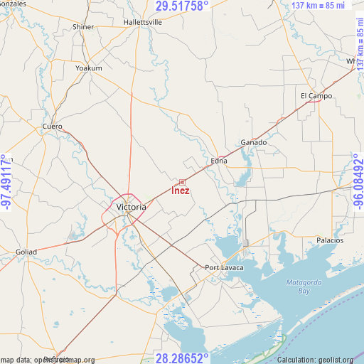
Inez GPS coordinates[2]
28° 54' 13.968" North, 96° 47' 16.944" West
| Map corner | latitude | longitude |
|---|---|---|
| Upper-left | 29.51758°, | -97.49117° |
| Center: | 28.90388°, | -96.78804° |
| Lower-right: | 28.28652°, | -96.08492° |
| Map W x H: | 136.9×136.9 km | = 85.1×85.1mi |
| max Lat: | 71.29058° ⇑95.4% North |
| Inez: | 28.90388° |
| min Lat: | ⇓4.6% South 19.06759° |
| min Long | Inez | max Long |
| -171.73463° | -96.78804° | -66.98998° |
| W 24.8%⇐ | ⇒75.2% E |
Elevation
Elevation of Inez is 22 m = 72 ft, and this is 272.8 m = 895 ft below average elevation for this country.
| Max E: |
3189 m = 10463 ft | 87.4% |
| Avg. | 294.8 m = 967 ft | |
| Inez | 22 m = 72 ft | |
Min E: |
-60 m = -197 ft | 12.6% |
See also: United States elevation on elevation.city.
Geographical zone
Inez is located in North temperate zone (between Tropic of Cancer and the Arctic Circle). Distance of this Northern Tropic circle is 607.9 km =377.7 mi to South.| Distance of | km | miles | from Inez |
|---|---|---|---|
| North Pole | 6793.3 | 4221.2 | to North |
| Arctic Circle | 4187.4 | 2601.9 | to North |
| Tropic Cancer | 607.9 | 377.7 | to South |
| Equator | 3213.8 | 1997 | to South |


Nearby cities:
15 places around Inez: (largest is in red/bold)
• Blessing
55.6 km =34.5 mi,  93°
93°
• Bloomington
30.2 km =18.8 mi,  199°
199°
• Cuero
53.1 km =33 mi,  293°
293°
• Edna
16.1 km =10 mi,  58°
58°
• Ganado
30.7 km =19.1 mi, 60°
• Lolita
25 km =15.5 mi,  106°
106°
• Louise
44 km =27.3 mi, 58°
• Palacios
59.7 km =37.1 mi, 111°
• Placedo
23.9 km =14.9 mi,  189°
189°
• Point Comfort
33.4 km =20.8 mi,  138°
138°
• Port Lavaca
35.8 km =22.2 mi,  153°
153°
• Quail Creek
32 km =19.9 mi,  243°
243°
• Seadrift
54.8 km =34.1 mi,  172°
172°
• Victoria
23.7 km =14.7 mi, 242°
• Yoakum
55.4 km =34.4 mi,  320°
320°
Sources, notices
• [Note1] Compared only with cities in United States existing in our database
• [Src1] Map data: © OpenStreetMap contributors (CC-BY-SA)
• [Src2] Other city data from geonames.org with taken over terms of usage.
• [Src3] Geographical zone / Annual Mean Temperature by Robert A. Rohde @ Wikipedia
