Quail Creek geodata
Quail Creek (Texas) is a populated place; located in United States in America/Chicago (GMT-5) time zone. With population of 1,628 people, there are 13181 cities with bigger population in this country. Compared to other cities in United States, 95.5% of cities are located further ↑North; 75.9% of cities are located further →East and 82.9% of cities have higher elevation than Quail Creek. Note1


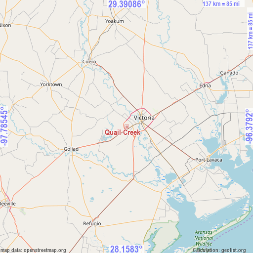
Quail Creek GPS coordinates[2]
28° 46' 35.04" North, 97° 4' 56.352" West
| Map corner | latitude | longitude |
|---|---|---|
| Upper-left | 29.39086°, | -97.78545° |
| Center: | 28.7764°, | -97.08232° |
| Lower-right: | 28.1583°, | -96.3792° |
| Map W x H: | 137×137 km | = 85.1×85.1mi |
| max Lat: | 71.29058° ⇑95.5% North |
| Quail Creek: | 28.7764° |
| min Lat: | ⇓4.5% South 19.06759° |
| min Long | Quail Creek | max Long |
| -171.73463° | -97.08232° | -66.98998° |
| W 24.1%⇐ | ⇒75.9% E |
Elevation
Elevation of Quail Creek is 35 m = 115 ft, and this is 259.8 m = 852 ft below average elevation for this country.
| Max E: |
3189 m = 10463 ft | 82.9% |
| Avg. | 294.8 m = 967 ft | |
| Quail Creek | 35 m = 115 ft | |
Min E: |
-60 m = -197 ft | 17.1% |
See also: United States elevation on elevation.city.
Geographical zone
Quail Creek is located in North temperate zone (between Tropic of Cancer and the Arctic Circle). Distance of this Northern Tropic circle is 593.7 km =368.9 mi to South.| Distance of | km | miles | from Quail Creek |
|---|---|---|---|
| North Pole | 6807.4 | 4229.9 | to North |
| Arctic Circle | 4201.5 | 2610.7 | to North |
| Tropic Cancer | 593.7 | 368.9 | to South |
| Equator | 3199.6 | 1988.1 | to South |


Nearby cities:
15 places around Quail Creek: (largest is in red/bold)
• Bloomington
23.4 km =14.5 mi,  127°
127°
• Cuero
40.6 km =25.2 mi,  330°
330°
• Edna
48.1 km =29.9 mi,  62°
62°
• Goliad
32.2 km =20 mi,  248°
248°
• Inez
32 km =19.9 mi, 63°
• Lolita
53.1 km =33 mi,  82°
82°
• Placedo
26.5 km =16.5 mi,  110°
110°
• Point Comfort
52 km =32.3 mi,  101°
101°
• Port Lavaca
48 km =29.8 mi, 111°
• Refugio
55.7 km =34.6 mi,  199°
199°
• Runge
62.6 km =38.9 mi,  280°
280°
• Seadrift
53.9 km =33.5 mi,  138°
138°
• Victoria
8.3 km =5.2 mi,  67°
67°
• Yoakum
57.3 km =35.6 mi,  353°
353°
• Yorktown
46.8 km =29.1 mi,  299°
299°
Sources, notices
• [Note1] Compared only with cities in United States existing in our database
• [Src1] Map data: © OpenStreetMap contributors (CC-BY-SA)
• [Src2] Other city data from geonames.org with taken over terms of usage.
• [Src3] Geographical zone / Annual Mean Temperature by Robert A. Rohde @ Wikipedia
