Guy geodata
Guy (Arkansas) is a populated place; located in United States in America/Chicago (GMT-5) time zone. With population of 718 people, there are 18511 cities with bigger population in this country. Compared to other cities in United States, 73.5% of cities are located further ↑North; 64.9% of cities are located further →East and 53% of cities have lower elevation than Guy. Note1
Administrative division(s):
- Level 1: Arkansas
- Level 2: Faulkner County
- Level 3: Township of California


Guy GPS coordinates[2]
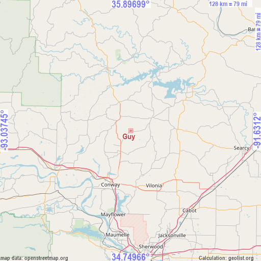
35° 19' 31.296" North, 92° 20' 3.552" West
| Map corner | latitude | longitude |
|---|---|---|
| Upper-left | 35.89699°, | -93.03745° |
| Center: | 35.32536°, | -92.33432° |
| Lower-right: | 34.74966°, | -91.6312° |
| Map W x H: | 127.6×127.6 km | = 79.3×79.3mi |
| max Lat: | 71.29058° ⇑73.5% North |
| Guy: | 35.32536° |
| min Lat: | ⇓26.5% South 19.06759° |
| min Long | Guy | max Long |
| -171.73463° | -92.33432° | -66.98998° |
| W 35.1%⇐ | ⇒64.9% E |
Elevation
Elevation of Guy is 210 m = 689 ft, and this is 84.8 m = 278 ft below average elevation for this country.
| Max E: |
3189 m = 10463 ft | 47% |
| Avg. | 294.8 m = 967 ft | |
| Guy | 210 m = 689 ft | |
Min E: |
-60 m = -197 ft | 53% |
See also: United States elevation on elevation.city.
Geographical zone
Guy is located in North temperate zone (between Tropic of Cancer and the Arctic Circle). Distance of this Northern Tropic circle is 1321.9 km =821.4 mi to South.| Distance of | km | miles | from Guy |
|---|---|---|---|
| North Pole | 6079.3 | 3777.5 | to North |
| Arctic Circle | 3473.4 | 2158.3 | to North |
| Tropic Cancer | 1321.9 | 821.4 | to South |
| Equator | 3927.8 | 2440.6 | to South |


Nearby cities:
15 places around Guy: (largest is in red/bold)
• Clinton
31.7 km =19.7 mi,  338°
338°
• Conway
28.1 km =17.5 mi,  200°
200°
• Fairfield Bay
30.3 km =18.8 mi,  9°
9°
• Greenbrier
11.3 km =7 mi,  205°
205°
• Greers Ferry
31.4 km =19.5 mi,  26°
26°
• Heber Springs
33.1 km =20.6 mi,  56°
56°
• Holland
18 km =11.2 mi,  162°
162°
• Mayflower
41.8 km =26 mi,  191°
191°
• Morrilton
42 km =26.1 mi,  242°
242°
• Pangburn
46.5 km =28.9 mi,  75°
75°
• Plumerville
33.3 km =20.7 mi, 236°
• Quitman
12.6 km =7.8 mi, 58°
• Tumbling Shoals
41.1 km =25.5 mi,  54°
54°
• Vilonia
29.2 km =18.1 mi, 156°
• Wooster
17.6 km =10.9 mi,  218°
218°
Sources, notices
• [Note1] Compared only with cities in United States existing in our database
• [Src1] Map data: © OpenStreetMap contributors (CC-BY-SA)
• [Src2] Other city data from geonames.org with taken over terms of usage.
• [Src3] Geographical zone / Annual Mean Temperature by Robert A. Rohde @ Wikipedia
