Greenbrier geodata
Greenbrier (Arkansas) is a populated place; located in United States in America/Chicago (GMT-5) time zone. With population of 5,296 people, there are 6911 cities with bigger population in this country. Compared to other cities in United States, 74.1% of cities are located further ↑North; 64.9% of cities are located further →East and 68% of cities have higher elevation than Greenbrier. Note1


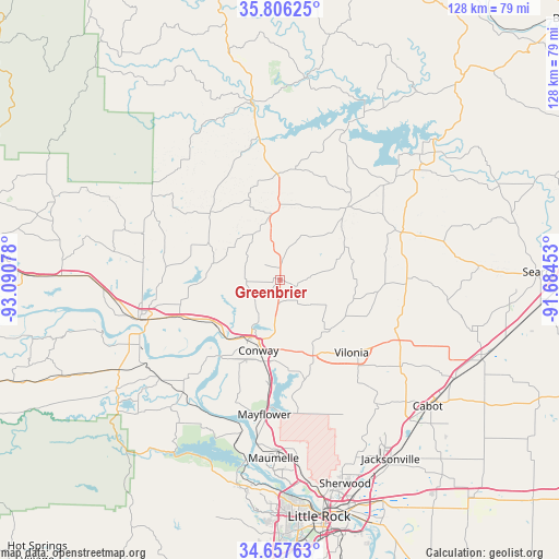
Greenbrier GPS coordinates[2]
35° 14' 2.292" North, 92° 23' 15.54" West
| Map corner | latitude | longitude |
|---|---|---|
| Upper-left | 35.80625°, | -93.09078° |
| Center: | 35.23397°, | -92.38765° |
| Lower-right: | 34.65763°, | -91.68453° |
| Map W x H: | 127.7×127.7 km | = 79.3×79.3mi |
| max Lat: | 71.29058° ⇑74.1% North |
| Greenbrier: | 35.23397° |
| min Lat: | ⇓25.9% South 19.06759° |
| min Long | Greenbrier | max Long |
| -171.73463° | -92.38765° | -66.98998° |
| W 35.1%⇐ | ⇒64.9% E |
Elevation
Elevation of Greenbrier is 112 m = 367 ft, and this is 182.8 m = 600 ft below average elevation for this country.
| Max E: |
3189 m = 10463 ft | 68% |
| Avg. | 294.8 m = 967 ft | |
| Greenbrier | 112 m = 367 ft | |
Min E: |
-60 m = -197 ft | 32% |
See also: United States elevation on elevation.city.
Geographical zone
Greenbrier is located in North temperate zone (between Tropic of Cancer and the Arctic Circle). Distance of this Northern Tropic circle is 1311.7 km =815.1 mi to South.| Distance of | km | miles | from Greenbrier |
|---|---|---|---|
| North Pole | 6089.4 | 3783.8 | to North |
| Arctic Circle | 3483.5 | 2164.5 | to North |
| Tropic Cancer | 1311.7 | 815.1 | to South |
| Equator | 3917.7 | 2434.3 | to South |


Nearby cities:
15 places around Greenbrier: (largest is in red/bold)
• Clinton
40.3 km =25 mi,  350°
350°
• Conway
16.9 km =10.5 mi,  197°
197°
• Fairfield Bay
41.3 km =25.7 mi,  13°
13°
• Gibson
41.3 km =25.7 mi,  160°
160°
• Guy
11.3 km =7 mi,  25°
25°
• Holland
12.5 km =7.8 mi,  123°
123°
• Maumelle
40.9 km =25.4 mi,  182°
182°
• Mayflower
31 km =19.3 mi,  186°
186°
• Morrilton
33.7 km =20.9 mi,  254°
254°
• Oppelo
37.6 km =23.4 mi, 246°
• Plumerville
24.4 km =15.2 mi, 250°
• Quitman
22.9 km =14.2 mi,  43°
43°
• Roland
38.4 km =23.9 mi, 195°
• Vilonia
23.3 km =14.5 mi,  135°
135°
• Wooster
7.2 km =4.5 mi,  240°
240°
Sources, notices
• [Note1] Compared only with cities in United States existing in our database
• [Src1] Map data: © OpenStreetMap contributors (CC-BY-SA)
• [Src2] Other city data from geonames.org with taken over terms of usage.
• [Src3] Geographical zone / Annual Mean Temperature by Robert A. Rohde @ Wikipedia
