Wooster geodata
Wooster (Arkansas) is a populated place; located in United States in America/Chicago (GMT-5) time zone. With population of 999 people, there are 16287 cities with bigger population in this country. Compared to other cities in United States, 74.3% of cities are located further ↑North; 65.1% of cities are located further →East and 70.3% of cities have higher elevation than Wooster. Note1


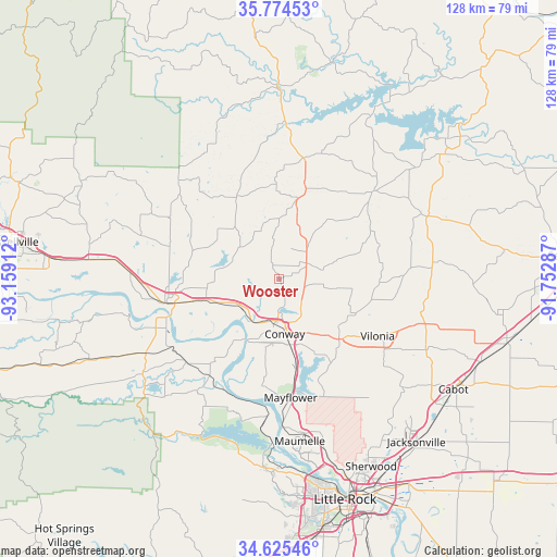
Wooster GPS coordinates[2]
35° 12' 7.308" North, 92° 27' 21.564" West
| Map corner | latitude | longitude |
|---|---|---|
| Upper-left | 35.77453°, | -93.15912° |
| Center: | 35.20203°, | -92.45599° |
| Lower-right: | 34.62546°, | -91.75287° |
| Map W x H: | 127.8×127.8 km | = 79.4×79.4mi |
| max Lat: | 71.29058° ⇑74.3% North |
| Wooster: | 35.20203° |
| min Lat: | ⇓25.7% South 19.06759° |
| min Long | Wooster | max Long |
| -171.73463° | -92.45599° | -66.98998° |
| W 34.9%⇐ | ⇒65.1% E |
Elevation
Elevation of Wooster is 99 m = 325 ft, and this is 195.8 m = 642 ft below average elevation for this country.
| Max E: |
3189 m = 10463 ft | 70.3% |
| Avg. | 294.8 m = 967 ft | |
| Wooster | 99 m = 325 ft | |
Min E: |
-60 m = -197 ft | 29.7% |
See also: United States elevation on elevation.city.
Geographical zone
Wooster is located in North temperate zone (between Tropic of Cancer and the Arctic Circle). Distance of this Northern Tropic circle is 1308.2 km =812.9 mi to South.| Distance of | km | miles | from Wooster |
|---|---|---|---|
| North Pole | 6093 | 3786 | to North |
| Arctic Circle | 3487.1 | 2166.8 | to North |
| Tropic Cancer | 1308.2 | 812.9 | to South |
| Equator | 3914.1 | 2432.1 | to South |


Nearby cities:
15 places around Wooster: (largest is in red/bold)
• Conway
12.7 km =7.9 mi,  174°
174°
• Gibson
40.6 km =25.2 mi,  150°
150°
• Greenbrier
7.2 km =4.5 mi,  60°
60°
• Guy
17.6 km =10.9 mi,  38°
38°
• Holland
16.9 km =10.5 mi,  101°
101°
• Maumelle
37.6 km =23.4 mi, 172°
• Mayflower
27.4 km =17 mi, 174°
• Morrilton
26.8 km =16.7 mi,  257°
257°
• Oppelo
30.5 km =19 mi,  248°
248°
• Perryville
38.4 km =23.9 mi,  235°
235°
• Plumerville
17.4 km =10.8 mi, 254°
• Quitman
29.8 km =18.5 mi,  47°
47°
• Roland
33.7 km =20.9 mi,  186°
186°
• Vilonia
26.1 km =16.2 mi,  120°
120°
• Wilson
43 km =26.7 mi,  271°
271°
Sources, notices
• [Note1] Compared only with cities in United States existing in our database
• [Src1] Map data: © OpenStreetMap contributors (CC-BY-SA)
• [Src2] Other city data from geonames.org with taken over terms of usage.
• [Src3] Geographical zone / Annual Mean Temperature by Robert A. Rohde @ Wikipedia
