Conway geodata
Conway (Arkansas) is a seat of a second-order administrative division; located in United States in America/Chicago (GMT-5) time zone. With population of 64,980 people, there are 663 cities with bigger population in this country. Compared to other cities in United States, 74.9% of cities are located further ↑North; 65.1% of cities are located further →East and 70.3% of cities have higher elevation than Conway. Note1


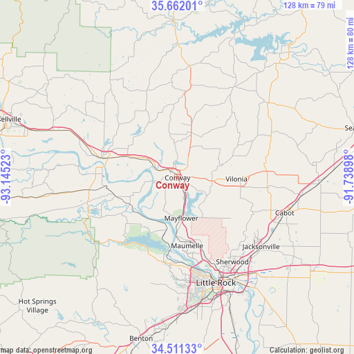
Conway GPS coordinates[2]
35° 5' 19.32" North, 92° 26' 31.56" West
| Map corner | latitude | longitude |
|---|---|---|
| Upper-left | 35.66201°, | -93.14523° |
| Center: | 35.0887°, | -92.4421° |
| Lower-right: | 34.51133°, | -91.73898° |
| Map W x H: | 127.9×127.9 km | = 79.5×79.5mi |
| max Lat: | 71.29058° ⇑74.9% North |
| Conway: | 35.0887° |
| min Lat: | ⇓25.1% South 19.06759° |
| min Long | Conway | max Long |
| -171.73463° | -92.4421° | -66.98998° |
| W 34.9%⇐ | ⇒65.1% E |
Elevation
Elevation of Conway is 99 m = 325 ft, and this is 195.8 m = 642 ft below average elevation for this country.
| Max E: |
3189 m = 10463 ft | 70.3% |
| Avg. | 294.8 m = 967 ft | |
| Conway | 99 m = 325 ft | |
Min E: |
-60 m = -197 ft | 29.7% |
See also: Conway elevation on elevation.city.
Geographical zone
Conway is located in North temperate zone (between Tropic of Cancer and the Arctic Circle). Distance of this Northern Tropic circle is 1295.6 km =805 mi to South.| Distance of | km | miles | from Conway |
|---|---|---|---|
| North Pole | 6105.6 | 3793.8 | to North |
| Arctic Circle | 3499.7 | 2174.6 | to North |
| Tropic Cancer | 1295.6 | 805 | to South |
| Equator | 3901.5 | 2424.3 | to South |


Nearby cities:
15 places around Conway: (largest is in red/bold)
• Gibson
29.5 km =18.3 mi,  140°
140°
• Gravel Ridge
33.5 km =20.8 mi, 136°
• Greenbrier
16.9 km =10.5 mi,  17°
17°
• Guy
28.1 km =17.5 mi, 20°
• Holland
17.9 km =11.1 mi,  58°
58°
• Little Rock Air Force Base
33.8 km =21 mi,  130°
130°
• Maumelle
24.9 km =15.5 mi,  172°
172°
• Mayflower
14.7 km =9.1 mi, 174°
• Morrilton
28.3 km =17.6 mi,  284°
284°
• Oppelo
29.7 km =18.5 mi,  272°
272°
• Perryville
34.1 km =21.2 mi,  254°
254°
• Plumerville
19.7 km =12.2 mi,  293°
293°
• Roland
21.5 km =13.4 mi,  193°
193°
• Vilonia
21.3 km =13.2 mi,  91°
91°
• Wooster
12.7 km =7.9 mi,  354°
354°
Sources, notices
• [Note1] Compared only with cities in United States existing in our database
• [Src1] Map data: © OpenStreetMap contributors (CC-BY-SA)
• [Src2] Other city data from geonames.org with taken over terms of usage.
• [Src3] Geographical zone / Annual Mean Temperature by Robert A. Rohde @ Wikipedia
