Berry geodata
Berry (Alabama) is a populated place; located in United States in America/Chicago (GMT-5) time zone. With population of 1,113 people, there are 15605 cities with bigger population in this country. Compared to other cities in United States, 82.3% of cities are located further ↑North; 51% of cities are located further →East and 62.7% of cities have higher elevation than Berry. Note1


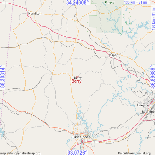
Berry GPS coordinates[2]
33° 39' 35.388" North, 87° 36' 0.036" West
| Map corner | latitude | longitude |
|---|---|---|
| Upper-left | 34.24308°, | -88.30314° |
| Center: | 33.65983°, | -87.60001° |
| Lower-right: | 33.0726°, | -86.89689° |
| Map W x H: | 130.1×130.1 km | = 80.8×80.8mi |
| max Lat: | 71.29058° ⇑82.3% North |
| Berry: | 33.65983° |
| min Lat: | ⇓17.7% South 19.06759° |
| min Long | Berry | max Long |
| -171.73463° | -87.60001° | -66.98998° |
| W 49%⇐ | ⇒51% E |
Elevation
Elevation of Berry is 140 m = 459 ft, and this is 154.8 m = 508 ft below average elevation for this country.
| Max E: |
3189 m = 10463 ft | 62.7% |
| Avg. | 294.8 m = 967 ft | |
| Berry | 140 m = 459 ft | |
Min E: |
-60 m = -197 ft | 37.3% |
See also: United States elevation on elevation.city.
Geographical zone
Berry is located in North temperate zone (between Tropic of Cancer and the Arctic Circle). Distance of this Northern Tropic circle is 1136.7 km =706.3 mi to South.| Distance of | km | miles | from Berry |
|---|---|---|---|
| North Pole | 6264.4 | 3892.5 | to North |
| Arctic Circle | 3658.6 | 2273.3 | to North |
| Tropic Cancer | 1136.7 | 706.3 | to South |
| Equator | 3742.6 | 2325.5 | to South |


Nearby cities:
15 places around Berry: (largest is in red/bold)
• Brilliant
43.2 km =26.8 mi,  340°
340°
• Carbon Hill
26.7 km =16.6 mi,  14°
14°
• Coker
46.7 km =29 mi,  190°
190°
• Cordova
40.1 km =24.9 mi,  73°
73°
• Dora
47.8 km =29.7 mi,  80°
80°
• Fayette
21.5 km =13.4 mi,  277°
277°
• Gordo
47.1 km =29.3 mi,  216°
216°
• Guin
44.7 km =27.8 mi,  319°
319°
• Jasper
35.4 km =22 mi,  57°
57°
• Lynn
43.3 km =26.9 mi, 6°
• Millport
45.8 km =28.5 mi,  256°
256°
• Northport
47.9 km =29.8 mi,  177°
177°
• Oakman
20.4 km =12.7 mi, 73°
• Parrish
30.2 km =18.8 mi, 74°
• Winfield
36 km =22.4 mi,  326°
326°
Sources, notices
• [Note1] Compared only with cities in United States existing in our database
• [Src1] Map data: © OpenStreetMap contributors (CC-BY-SA)
• [Src2] Other city data from geonames.org with taken over terms of usage.
• [Src3] Geographical zone / Annual Mean Temperature by Robert A. Rohde @ Wikipedia
