Gordo geodata
Gordo (Alabama) is a populated place; located in United States in America/Chicago (GMT-5) time zone. With population of 1,687 people, there are 12958 cities with bigger population in this country. Compared to other cities in United States, 83.9% of cities are located further ↑North; 52.4% of cities are located further →East and 72.7% of cities have higher elevation than Gordo. Note1


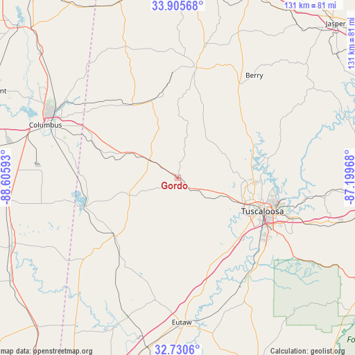
Gordo GPS coordinates[2]
33° 19' 12.432" North, 87° 54' 10.08" West
| Map corner | latitude | longitude |
|---|---|---|
| Upper-left | 33.90568°, | -88.60593° |
| Center: | 33.32012°, | -87.9028° |
| Lower-right: | 32.7306°, | -87.19968° |
| Map W x H: | 130.7×130.7 km | = 81.2×81.2mi |
| max Lat: | 71.29058° ⇑83.9% North |
| Gordo: | 33.32012° |
| min Lat: | ⇓16.1% South 19.06759° |
| min Long | Gordo | max Long |
| -171.73463° | -87.9028° | -66.98998° |
| W 47.6%⇐ | ⇒52.4% E |
Elevation
Elevation of Gordo is 85 m = 279 ft, and this is 209.8 m = 688 ft below average elevation for this country.
| Max E: |
3189 m = 10463 ft | 72.7% |
| Avg. | 294.8 m = 967 ft | |
| Gordo | 85 m = 279 ft | |
Min E: |
-60 m = -197 ft | 27.3% |
See also: United States elevation on elevation.city.
Geographical zone
Gordo is located in North temperate zone (between Tropic of Cancer and the Arctic Circle). Distance of this Northern Tropic circle is 1098.9 km =682.8 mi to South.| Distance of | km | miles | from Gordo |
|---|---|---|---|
| North Pole | 6302.2 | 3916 | to North |
| Arctic Circle | 3696.3 | 2296.8 | to North |
| Tropic Cancer | 1098.9 | 682.8 | to South |
| Equator | 3704.9 | 2302.1 | to South |


Nearby cities:
15 places around Gordo: (largest is in red/bold)
• Aliceville
31.4 km =19.5 mi,  227°
227°
• Berry
47.1 km =29.3 mi,  36°
36°
• Carrollton
19 km =11.8 mi,  250°
250°
• Coker
21.6 km =13.4 mi,  112°
112°
• Columbus
52.4 km =32.6 mi,  291°
291°
• Fayette
41.1 km =25.5 mi,  9°
9°
• Holt
40.1 km =24.9 mi,  103°
103°
• Millport
31.7 km =19.7 mi,  328°
328°
• Moundville
43.9 km =27.3 mi,  144°
144°
• New Hope
42.7 km =26.5 mi, 292°
• Northport
31.9 km =19.8 mi, 108°
• Pickensville
35.3 km =21.9 mi, 253°
• Reform
12.3 km =7.6 mi,  301°
301°
• Tuscaloosa
33.4 km =20.8 mi, 111°
• Vernon
52.2 km =32.4 mi,  338°
338°
Sources, notices
• [Note1] Compared only with cities in United States existing in our database
• [Src1] Map data: © OpenStreetMap contributors (CC-BY-SA)
• [Src2] Other city data from geonames.org with taken over terms of usage.
• [Src3] Geographical zone / Annual Mean Temperature by Robert A. Rohde @ Wikipedia
