Coker geodata
Coker (Alabama) is a populated place; located in United States in America/Chicago (GMT-5) time zone. With population of 978 people, there are 16430 cities with bigger population in this country. Compared to other cities in United States, 84.1% of cities are located further ↑North; 51.4% of cities are located further →East and 76.3% of cities have higher elevation than Coker. Note1


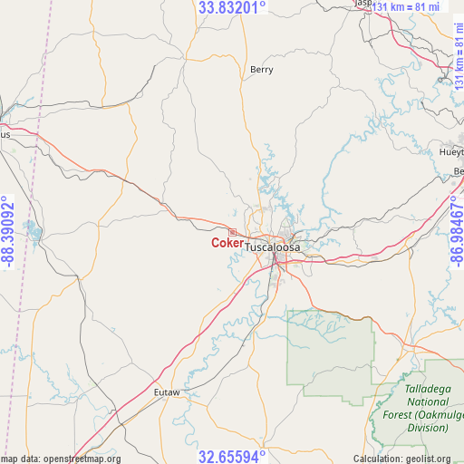
Coker GPS coordinates[2]
33° 14' 45.42" North, 87° 41' 16.044" West
| Map corner | latitude | longitude |
|---|---|---|
| Upper-left | 33.83201°, | -88.39092° |
| Center: | 33.24595°, | -87.68779° |
| Lower-right: | 32.65594°, | -86.98467° |
| Map W x H: | 130.8×130.8 km | = 81.3×81.3mi |
| max Lat: | 71.29058° ⇑84.1% North |
| Coker: | 33.24595° |
| min Lat: | ⇓15.9% South 19.06759° |
| min Long | Coker | max Long |
| -171.73463° | -87.68779° | -66.98998° |
| W 48.6%⇐ | ⇒51.4% E |
Elevation
Elevation of Coker is 64 m = 210 ft, and this is 230.8 m = 757 ft below average elevation for this country.
| Max E: |
3189 m = 10463 ft | 76.3% |
| Avg. | 294.8 m = 967 ft | |
| Coker | 64 m = 210 ft | |
Min E: |
-60 m = -197 ft | 23.7% |
See also: United States elevation on elevation.city.
Geographical zone
Coker is located in North temperate zone (between Tropic of Cancer and the Arctic Circle). Distance of this Northern Tropic circle is 1090.7 km =677.7 mi to South.| Distance of | km | miles | from Coker |
|---|---|---|---|
| North Pole | 6310.5 | 3921.2 | to North |
| Arctic Circle | 3704.6 | 2301.9 | to North |
| Tropic Cancer | 1090.7 | 677.7 | to South |
| Equator | 3696.6 | 2297 | to South |


Nearby cities:
15 places around Coker: (largest is in red/bold)
• Aliceville
45 km =28 mi,  253°
253°
• Berry
46.7 km =29 mi,  10°
10°
• Brookwood
34.1 km =21.2 mi,  88°
88°
• Carrollton
37.9 km =23.5 mi,  272°
272°
• Coaling
33.7 km =20.9 mi,  106°
106°
• Eutaw
48.8 km =30.3 mi,  202°
202°
• Gordo
21.6 km =13.4 mi,  292°
292°
• Holt
19 km =11.8 mi, 94°
• Moundville
28.1 km =17.5 mi,  168°
168°
• North Bibb
50 km =31.1 mi,  95°
95°
• Northport
10.5 km =6.5 mi, 100°
• Reform
33.8 km =21 mi,  295°
295°
• Tuscaloosa
11.7 km =7.3 mi, 109°
• Vance
43 km =26.7 mi, 100°
• Woodstock
50.2 km =31.2 mi, 94°
Sources, notices
• [Note1] Compared only with cities in United States existing in our database
• [Src1] Map data: © OpenStreetMap contributors (CC-BY-SA)
• [Src2] Other city data from geonames.org with taken over terms of usage.
• [Src3] Geographical zone / Annual Mean Temperature by Robert A. Rohde @ Wikipedia
