Joppa geodata
Joppa (Alabama) is a populated place; located in United States in America/Chicago (GMT-5) time zone. With population of 501 people, there are 20887 cities with bigger population in this country. Compared to other cities in United States, 78.5% of cities are located further ↑North; 51.4% of cities are located further ←West and 74.2% of cities have lower elevation than Joppa. Note1


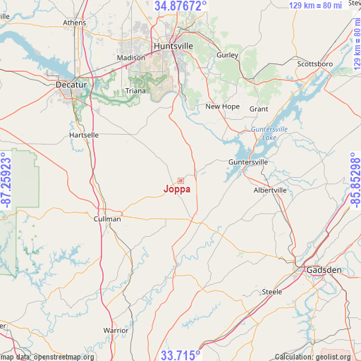
Joppa GPS coordinates[2]
34° 17' 52.332" North, 86° 33' 21.96" West
| Map corner | latitude | longitude |
|---|---|---|
| Upper-left | 34.87672°, | -87.25923° |
| Center: | 34.29787°, | -86.5561° |
| Lower-right: | 33.715°, | -85.85298° |
| Map W x H: | 129.2×129.2 km | = 80.3×80.3mi |
| max Lat: | 71.29058° ⇑78.5% North |
| Joppa: | 34.29787° |
| min Lat: | ⇓21.5% South 19.06759° |
| min Long | Joppa | max Long |
| -171.73463° | -86.5561° | -66.98998° |
| W 51.4%⇐ | ⇒48.6% E |
Elevation
Elevation of Joppa is 308 m = 1010 ft, and this is 13.2 m = 43 ft above average elevation for this country.
| Max E: |
3189 m = 10463 ft | 25.8% |
| Joppa | 308 m 1010 ft | |
| Avg. | 294.8 m = 967 ft | |
Min E: |
-60 m = -197 ft | 74.2% |
See also: United States elevation on elevation.city.
Geographical zone
Joppa is located in North temperate zone (between Tropic of Cancer and the Arctic Circle). Distance of this Northern Tropic circle is 1207.6 km =750.4 mi to South.| Distance of | km | miles | from Joppa |
|---|---|---|---|
| North Pole | 6193.5 | 3848.5 | to North |
| Arctic Circle | 3587.6 | 2229.2 | to North |
| Tropic Cancer | 1207.6 | 750.4 | to South |
| Equator | 3813.6 | 2369.7 | to South |


Nearby cities:
15 places around Joppa: (largest is in red/bold)
• Albertville
32.1 km =19.9 mi,  95°
95°
• Arab
6 km =3.7 mi,  67°
67°
• Baileyton
6.5 km =4 mi,  232°
232°
• Blountsville
24.3 km =15.1 mi,  187°
187°
• Cullman
29.8 km =18.5 mi,  242°
242°
• Douglas
25.4 km =15.8 mi,  122°
122°
• Eva
19 km =11.8 mi,  281°
281°
• Guntersville
24.9 km =15.5 mi, 74°
• Hanceville
32.8 km =20.4 mi,  216°
216°
• Holly Pond
14.8 km =9.2 mi,  201°
201°
• New Hope
30.5 km =19 mi,  29°
29°
• Snead
24.7 km =15.3 mi,  143°
143°
• Somerville
29.6 km =18.4 mi,  311°
311°
• South Vinemont
29.1 km =18.1 mi,  256°
256°
• Susan Moore
26.6 km =16.5 mi,  153°
153°
Sources, notices
• [Note1] Compared only with cities in United States existing in our database
• [Src1] Map data: © OpenStreetMap contributors (CC-BY-SA)
• [Src2] Other city data from geonames.org with taken over terms of usage.
• [Src3] Geographical zone / Annual Mean Temperature by Robert A. Rohde @ Wikipedia
