Clanton geodata
Clanton (Alabama) is a seat of a second-order administrative division; located in United States in America/Chicago (GMT-5) time zone. With population of 8,844 people, there are 4863 cities with bigger population in this country. Compared to other cities in United States, 85.8% of cities are located further ↑North; 51.2% of cities are located further ←West and 55.5% of cities have higher elevation than Clanton. Note1


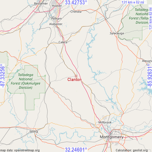
Clanton GPS coordinates[2]
32° 50' 19.464" North, 86° 37' 45.948" West
| Map corner | latitude | longitude |
|---|---|---|
| Upper-left | 33.42753°, | -87.33256° |
| Center: | 32.83874°, | -86.62943° |
| Lower-right: | 32.24601°, | -85.92631° |
| Map W x H: | 131.4×131.4 km | = 81.6×81.6mi |
| max Lat: | 71.29058° ⇑85.8% North |
| Clanton: | 32.83874° |
| min Lat: | ⇓14.2% South 19.06759° |
| min Long | Clanton | max Long |
| -171.73463° | -86.62943° | -66.98998° |
| W 51.2%⇐ | ⇒48.8% E |
Elevation
Elevation of Clanton is 178 m = 584 ft, and this is 116.8 m = 383 ft below average elevation for this country.
| Max E: |
3189 m = 10463 ft | 55.5% |
| Avg. | 294.8 m = 967 ft | |
| Clanton | 178 m = 584 ft | |
Min E: |
-60 m = -197 ft | 44.5% |
See also: United States elevation on elevation.city.
Geographical zone
Clanton is located in North temperate zone (between Tropic of Cancer and the Arctic Circle). Distance of this Northern Tropic circle is 1045.4 km =649.6 mi to South.| Distance of | km | miles | from Clanton |
|---|---|---|---|
| North Pole | 6355.7 | 3949.2 | to North |
| Arctic Circle | 3749.8 | 2330 | to North |
| Tropic Cancer | 1045.4 | 649.6 | to South |
| Equator | 3651.3 | 2268.8 | to South |


Nearby cities:
15 places around Clanton: (largest is in red/bold)
• Calera
31.6 km =19.6 mi,  338°
338°
• Columbiana
37.8 km =23.5 mi,  3°
3°
• Deatsville
33.7 km =20.9 mi,  139°
139°
• Elmore
44.5 km =27.7 mi, 138°
• Fayetteville
40 km =24.9 mi,  31°
31°
• Holtville
36.2 km =22.5 mi,  128°
128°
• Jemison
17.4 km =10.8 mi,  320°
320°
• Maplesville
23.5 km =14.6 mi,  256°
256°
• Marbury
21.3 km =13.2 mi, 135°
• Montevallo
36.4 km =22.6 mi, 323°
• Pine Level
32.2 km =20 mi,  151°
151°
• Rockford
38.7 km =24 mi,  81°
81°
• Shelby
30.5 km =19 mi,  7°
7°
• Thorsby
11.8 km =7.3 mi, 316°
• Wilton
35.6 km =22.1 mi, 318°
Sources, notices
• [Note1] Compared only with cities in United States existing in our database
• [Src1] Map data: © OpenStreetMap contributors (CC-BY-SA)
• [Src2] Other city data from geonames.org with taken over terms of usage.
• [Src3] Geographical zone / Annual Mean Temperature by Robert A. Rohde @ Wikipedia
