Alma geodata
Alma (Arkansas) is a populated place; located in United States in America/Chicago (GMT-5) time zone. With population of 5,575 people, there are 6699 cities with bigger population in this country. Compared to other cities in United States, 72.8% of cities are located further ↑North; 69.2% of cities are located further →East and 64% of cities have higher elevation than Alma. Note1


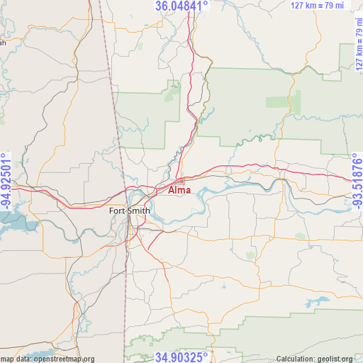
Alma GPS coordinates[2]
35° 28' 40.332" North, 94° 13' 18.768" West
| Map corner | latitude | longitude |
|---|---|---|
| Upper-left | 36.04841°, | -94.92501° |
| Center: | 35.47787°, | -94.22188° |
| Lower-right: | 34.90325°, | -93.51876° |
| Map W x H: | 127.3×127.3 km | = 79.1×79.1mi |
| max Lat: | 71.29058° ⇑72.8% North |
| Alma: | 35.47787° |
| min Lat: | ⇓27.2% South 19.06759° |
| min Long | Alma | max Long |
| -171.73463° | -94.22188° | -66.98998° |
| W 30.8%⇐ | ⇒69.2% E |
Elevation
Elevation of Alma is 133 m = 436 ft, and this is 161.8 m = 531 ft below average elevation for this country.
| Max E: |
3189 m = 10463 ft | 64% |
| Avg. | 294.8 m = 967 ft | |
| Alma | 133 m = 436 ft | |
Min E: |
-60 m = -197 ft | 36% |
See also: United States elevation on elevation.city.
Geographical zone
Alma is located in North temperate zone (between Tropic of Cancer and the Arctic Circle). Distance of this Northern Tropic circle is 1338.9 km =832 mi to South.| Distance of | km | miles | from Alma |
|---|---|---|---|
| North Pole | 6062.3 | 3766.9 | to North |
| Arctic Circle | 3456.4 | 2147.7 | to North |
| Tropic Cancer | 1338.9 | 832 | to South |
| Equator | 3944.8 | 2451.2 | to South |


Nearby cities:
15 places around Alma: (largest is in red/bold)
• Arkoma
23.6 km =14.7 mi,  234°
234°
• Barling
18.4 km =11.4 mi,  203°
203°
• Bonanza
32.4 km =20.1 mi,  214°
214°
• Cedarville
16.6 km =10.3 mi,  307°
307°
• Charleston
26.2 km =16.3 mi,  140°
140°
• Dyer
7.8 km =4.8 mi,  78°
78°
• Fort Smith
19 km =11.8 mi,  237°
237°
• Greenwood
29.3 km =18.2 mi,  186°
186°
• Kibler
5.4 km =3.4 mi, 189°
• Lavaca
16.4 km =10.2 mi,  164°
164°
• Mountainburg
18.2 km =11.3 mi,  15°
15°
• Mulberry
15.6 km =9.7 mi, 80°
• Remy
28.4 km =17.6 mi,  265°
265°
• Roland
27.3 km =17 mi,  256°
256°
• Van Buren
12.3 km =7.6 mi,  248°
248°
Sources, notices
• [Note1] Compared only with cities in United States existing in our database
• [Src1] Map data: © OpenStreetMap contributors (CC-BY-SA)
• [Src2] Other city data from geonames.org with taken over terms of usage.
• [Src3] Geographical zone / Annual Mean Temperature by Robert A. Rohde @ Wikipedia
