Van Buren geodata
Van Buren (Arkansas) is a seat of a second-order administrative division; located in United States in America/Chicago (GMT-5) time zone. With population of 23,081 people, there are 2187 cities with bigger population in this country. Compared to other cities in United States, 73% of cities are located further ↑North; 69.5% of cities are located further →East and 65.2% of cities have higher elevation than Van Buren. Note1
Administrative division(s):
- Level 1: Arkansas
- Level 2: Crawford County
- Level 3: Township of Van Buren


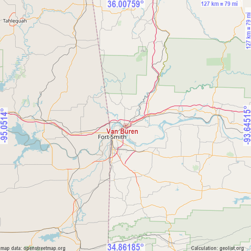
Van Buren GPS coordinates[2]
35° 26' 12.336" North, 94° 20' 53.772" West
| Map corner | latitude | longitude |
|---|---|---|
| Upper-left | 36.00759°, | -95.0514° |
| Center: | 35.43676°, | -94.34827° |
| Lower-right: | 34.86185°, | -93.64515° |
| Map W x H: | 127.4×127.4 km | = 79.2×79.2mi |
| max Lat: | 71.29058° ⇑73% North |
| Van Buren: | 35.43676° |
| min Lat: | ⇓27% South 19.06759° |
| min Long | Van Buren | max Long |
| -171.73463° | -94.34827° | -66.98998° |
| W 30.5%⇐ | ⇒69.5% E |
Elevation
Elevation of Van Buren is 127 m = 417 ft, and this is 167.8 m = 551 ft below average elevation for this country.
| Max E: |
3189 m = 10463 ft | 65.2% |
| Avg. | 294.8 m = 967 ft | |
| Van Buren | 127 m = 417 ft | |
Min E: |
-60 m = -197 ft | 34.8% |
See also: United States elevation on elevation.city.
Geographical zone
Van Buren is located in North temperate zone (between Tropic of Cancer and the Arctic Circle). Distance of this Northern Tropic circle is 1334.3 km =829.1 mi to South.| Distance of | km | miles | from Van Buren |
|---|---|---|---|
| North Pole | 6066.9 | 3769.8 | to North |
| Arctic Circle | 3461 | 2150.6 | to North |
| Tropic Cancer | 1334.3 | 829.1 | to South |
| Equator | 3940.2 | 2448.3 | to South |


Nearby cities:
15 places around Van Buren: (largest is in red/bold)
• Alma
12.3 km =7.6 mi,  68°
68°
• Arkoma
12 km =7.5 mi,  220°
220°
• Barling
13.1 km =8.1 mi,  161°
161°
• Bonanza
23.1 km =14.4 mi,  197°
197°
• Cedarville
14.9 km =9.3 mi,  353°
353°
• Dyer
20 km =12.4 mi, 72°
• Fort Smith
7.3 km =4.5 mi, 218°
• Greenwood
26 km =16.2 mi, 161°
• Kibler
10.6 km =6.6 mi,  93°
93°
• Lavaca
19.4 km =12.1 mi,  125°
125°
• Mountainburg
27.5 km =17.1 mi,  36°
36°
• Muldrow
23 km =14.3 mi,  261°
261°
• Pocola
25.7 km =16 mi,  207°
207°
• Remy
17 km =10.6 mi,  277°
277°
• Roland
15.2 km =9.4 mi, 263°
Sources, notices
• [Note1] Compared only with cities in United States existing in our database
• [Src1] Map data: © OpenStreetMap contributors (CC-BY-SA)
• [Src2] Other city data from geonames.org with taken over terms of usage.
• [Src3] Geographical zone / Annual Mean Temperature by Robert A. Rohde @ Wikipedia
