Lavaca geodata
Lavaca (Arkansas) is a populated place; located in United States in America/Chicago (GMT-5) time zone. With population of 2,404 people, there are 10838 cities with bigger population in this country. Compared to other cities in United States, 73.5% of cities are located further ↑North; 69% of cities are located further →East and 63.7% of cities have higher elevation than Lavaca. Note1
Administrative division(s):
- Level 1: Arkansas
- Level 2: Sebastian County
- Level 3: Township of Big Creek


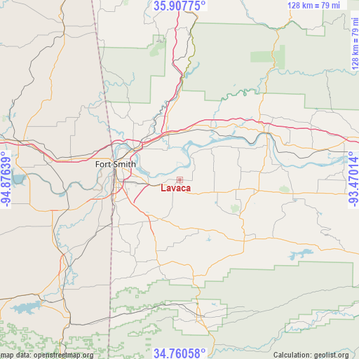
Lavaca GPS coordinates[2]
35° 20' 10.32" North, 94° 10' 23.736" West
| Map corner | latitude | longitude |
|---|---|---|
| Upper-left | 35.90775°, | -94.87639° |
| Center: | 35.3362°, | -94.17326° |
| Lower-right: | 34.76058°, | -93.47014° |
| Map W x H: | 127.6×127.6 km | = 79.3×79.3mi |
| max Lat: | 71.29058° ⇑73.5% North |
| Lavaca: | 35.3362° |
| min Lat: | ⇓26.5% South 19.06759° |
| min Long | Lavaca | max Long |
| -171.73463° | -94.17326° | -66.98998° |
| W 31%⇐ | ⇒69% E |
Elevation
Elevation of Lavaca is 135 m = 443 ft, and this is 159.8 m = 524 ft below average elevation for this country.
| Max E: |
3189 m = 10463 ft | 63.7% |
| Avg. | 294.8 m = 967 ft | |
| Lavaca | 135 m = 443 ft | |
Min E: |
-60 m = -197 ft | 36.3% |
See also: United States elevation on elevation.city.
Geographical zone
Lavaca is located in North temperate zone (between Tropic of Cancer and the Arctic Circle). Distance of this Northern Tropic circle is 1323.1 km =822.1 mi to South.| Distance of | km | miles | from Lavaca |
|---|---|---|---|
| North Pole | 6078 | 3776.7 | to North |
| Arctic Circle | 3472.2 | 2157.5 | to North |
| Tropic Cancer | 1323.1 | 822.1 | to South |
| Equator | 3929 | 2441.4 | to South |


Nearby cities:
15 places around Lavaca: (largest is in red/bold)
• Alma
16.4 km =10.2 mi,  344°
344°
• Arkoma
23.7 km =14.7 mi,  274°
274°
• Barling
11.7 km =7.3 mi,  264°
264°
• Bonanza
25.3 km =15.7 mi,  244°
244°
• Cedarville
31.3 km =19.4 mi,  325°
325°
• Charleston
13.2 km =8.2 mi,  109°
109°
• Dyer
17.7 km =11 mi,  10°
10°
• Fort Smith
21.2 km =13.2 mi,  285°
285°
• Greenwood
15.4 km =9.6 mi,  209°
209°
• Hackett
27 km =16.8 mi,  233°
233°
• Huntington
29.4 km =18.3 mi,  196°
196°
• Kibler
11.7 km =7.3 mi, 333°
• Mulberry
21.4 km =13.3 mi,  31°
31°
• Pocola
30 km =18.6 mi,  247°
247°
• Van Buren
19.4 km =12.1 mi,  305°
305°
Sources, notices
• [Note1] Compared only with cities in United States existing in our database
• [Src1] Map data: © OpenStreetMap contributors (CC-BY-SA)
• [Src2] Other city data from geonames.org with taken over terms of usage.
• [Src3] Geographical zone / Annual Mean Temperature by Robert A. Rohde @ Wikipedia
