Sheridan geodata
Sheridan (Arkansas) is a seat of a second-order administrative division; located in United States in America/Chicago (GMT-5) time zone. With population of 4,812 people, there are 7341 cities with bigger population in this country. Compared to other cities in United States, 78.4% of cities are located further ↑North; 65% of cities are located further →East and 72% of cities have higher elevation than Sheridan. Note1
Administrative division(s):
- Level 1: Arkansas
- Level 2: Grant County
- Level 3: Township of Merry Green


Sheridan GPS coordinates[2]
34° 18' 25.344" North, 92° 24' 4.572" West
| Map corner | latitude | longitude |
|---|---|---|
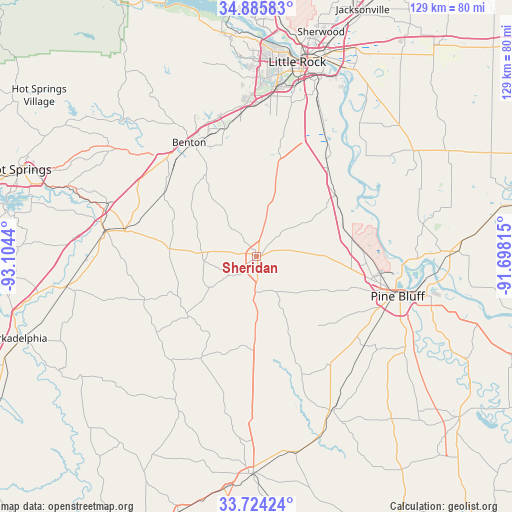
| Upper-left | 34.88583°, | -93.1044° |
| Center: | 34.30704°, | -92.40127° |
| Lower-right: | 33.72424°, | -91.69815° |
| Map W x H: | 129.2×129.2 km | = 80.3×80.3mi |
| max Lat: | 71.29058° ⇑78.4% North |
| Sheridan: | 34.30704° |
| min Lat: | ⇓21.6% South 19.06759° |
| min Long | Sheridan | max Long |
| -171.73463° | -92.40127° | -66.98998° |
| W 35%⇐ | ⇒65% E |
Elevation
Elevation of Sheridan is 89 m = 292 ft, and this is 205.8 m = 675 ft below average elevation for this country.
| Max E: |
3189 m = 10463 ft | 72% |
| Avg. | 294.8 m = 967 ft | |
| Sheridan | 89 m = 292 ft | |
Min E: |
-60 m = -197 ft | 28% |
See also: United States elevation on elevation.city.
Geographical zone
Sheridan is located in North temperate zone (between Tropic of Cancer and the Arctic Circle). Distance of this Northern Tropic circle is 1208.7 km =751.1 mi to South.| Distance of | km | miles | from Sheridan |
|---|---|---|---|
| North Pole | 6192.5 | 3847.8 | to North |
| Arctic Circle | 3586.6 | 2228.6 | to North |
| Tropic Cancer | 1208.7 | 751.1 | to South |
| Equator | 3814.6 | 2370.3 | to South |


Nearby cities:
15 places around Sheridan: (largest is in red/bold)
• Alexander
36 km =22.4 mi,  354°
354°
• Benton
33.3 km =20.7 mi,  329°
329°
• Bryant
33.1 km =20.6 mi, 345°
• East End
27.6 km =17.1 mi,  11°
11°
• Haskell
30.5 km =19 mi,  315°
315°
• Landmark
34.6 km =21.5 mi, 12°
• Leola
23.2 km =14.4 mi,  228°
228°
• Malvern
38.3 km =23.8 mi,  279°
279°
• Pine Bluff
37.6 km =23.4 mi,  103°
103°
• Redfield
25.2 km =15.7 mi,  52°
52°
• Shannon Hills
34.8 km =21.6 mi,  0°
0°
• Sulphur Springs
29.1 km =18.1 mi,  118°
118°
• Traskwood
28.1 km =17.5 mi,  304°
304°
• White Hall
28.7 km =17.8 mi, 97°
• Wrightsville
36.9 km =22.9 mi,  27°
27°
Sources, notices
• [Note1] Compared only with cities in United States existing in our database
• [Src1] Map data: © OpenStreetMap contributors (CC-BY-SA)
• [Src2] Other city data from geonames.org with taken over terms of usage.
• [Src3] Geographical zone / Annual Mean Temperature by Robert A. Rohde @ Wikipedia
