Lowell geodata
Lowell (Arkansas) is a populated place; located in United States in America/Chicago (GMT-5) time zone. With population of 8,549 people, there are 4990 cities with bigger population in this country. Compared to other cities in United States, 69.1% of cities are located further ↑North; 68.9% of cities are located further →East and 84.5% of cities have lower elevation than Lowell. Note1


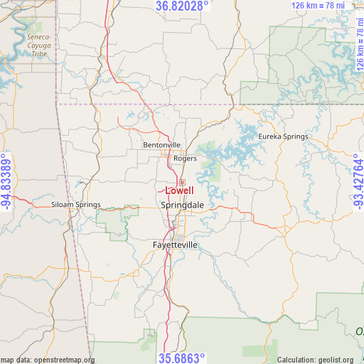
Lowell GPS coordinates[2]
36° 15' 19.26" North, 94° 7' 50.736" West
| Map corner | latitude | longitude |
|---|---|---|
| Upper-left | 36.82028°, | -94.83389° |
| Center: | 36.25535°, | -94.13076° |
| Lower-right: | 35.6863°, | -93.42764° |
| Map W x H: | 126.1×126.1 km | = 78.4×78.4mi |
| max Lat: | 71.29058° ⇑69.1% North |
| Lowell: | 36.25535° |
| min Lat: | ⇓30.9% South 19.06759° |
| min Long | Lowell | max Long |
| -171.73463° | -94.13076° | -66.98998° |
| W 31.1%⇐ | ⇒68.9% E |
Elevation
Elevation of Lowell is 413 m = 1355 ft, and this is 118.2 m = 388 ft above average elevation for this country.
| Max E: |
3189 m = 10463 ft | 15.5% |
| Lowell | 413 m 1355 ft | |
| Avg. | 294.8 m = 967 ft | |
Min E: |
-60 m = -197 ft | 84.5% |
See also: United States elevation on elevation.city.
Geographical zone
Lowell is located in North temperate zone (between Tropic of Cancer and the Arctic Circle). Distance of this Northern Tropic circle is 1425.3 km =885.6 mi to South.| Distance of | km | miles | from Lowell |
|---|---|---|---|
| North Pole | 5975.8 | 3713.2 | to North |
| Arctic Circle | 3370 | 2094 | to North |
| Tropic Cancer | 1425.3 | 885.6 | to South |
| Equator | 4031.2 | 2504.9 | to South |


Nearby cities:
15 places around Lowell: (largest is in red/bold)
• Avoca
17.2 km =10.7 mi,  18°
18°
• Bentonville
14.8 km =9.2 mi,  331°
331°
• Bethel Heights
4.6 km =2.9 mi,  178°
178°
• Cave Springs
9.1 km =5.7 mi,  275°
275°
• Centerton
18.1 km =11.2 mi,  310°
310°
• Elm Springs
10.8 km =6.7 mi,  239°
239°
• Fayetteville
21.6 km =13.4 mi,  186°
186°
• Goshen
21.2 km =13.2 mi,  143°
143°
• Highfill
20.4 km =12.7 mi,  271°
271°
• Johnson
14 km =8.7 mi, 192°
• Little Flock
14.5 km =9 mi,  358°
358°
• Prairie Creek
11.4 km =7.1 mi,  32°
32°
• Rogers
8.6 km =5.3 mi,  7°
7°
• Springdale
7.6 km =4.7 mi, 178°
• Tontitown
12.6 km =7.8 mi,  226°
226°
Sources, notices
• [Note1] Compared only with cities in United States existing in our database
• [Src1] Map data: © OpenStreetMap contributors (CC-BY-SA)
• [Src2] Other city data from geonames.org with taken over terms of usage.
• [Src3] Geographical zone / Annual Mean Temperature by Robert A. Rohde @ Wikipedia
