Harrisburg geodata
Harrisburg (Arkansas) is a seat of a second-order administrative division; located in United States in America/Chicago (GMT-5) time zone. With population of 2,302 people, there are 11073 cities with bigger population in this country. Compared to other cities in United States, 72.4% of cities are located further ↑North; 61.5% of cities are located further →East and 71.1% of cities have higher elevation than Harrisburg. Note1


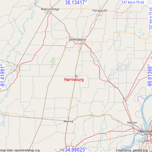
Harrisburg GPS coordinates[2]
35° 33' 51.3" North, 90° 43' 0.408" West
| Map corner | latitude | longitude |
|---|---|---|
| Upper-left | 36.13417°, | -91.41991° |
| Center: | 35.56425°, | -90.71678° |
| Lower-right: | 34.99025°, | -90.01366° |
| Map W x H: | 127.2×127.2 km | = 79×79mi |
| max Lat: | 71.29058° ⇑72.4% North |
| Harrisburg: | 35.56425° |
| min Lat: | ⇓27.6% South 19.06759° |
| min Long | Harrisburg | max Long |
| -171.73463° | -90.71678° | -66.98998° |
| W 38.5%⇐ | ⇒61.5% E |
Elevation
Elevation of Harrisburg is 94 m = 308 ft, and this is 200.8 m = 659 ft below average elevation for this country.
| Max E: |
3189 m = 10463 ft | 71.1% |
| Avg. | 294.8 m = 967 ft | |
| Harrisburg | 94 m = 308 ft | |
Min E: |
-60 m = -197 ft | 28.9% |
See also: United States elevation on elevation.city.
Geographical zone
Harrisburg is located in North temperate zone (between Tropic of Cancer and the Arctic Circle). Distance of this Northern Tropic circle is 1348.5 km =837.9 mi to South.| Distance of | km | miles | from Harrisburg |
|---|---|---|---|
| North Pole | 6052.7 | 3761 | to North |
| Arctic Circle | 3446.8 | 2141.7 | to North |
| Tropic Cancer | 1348.5 | 837.9 | to South |
| Equator | 3954.4 | 2457.1 | to South |


Nearby cities:
15 places around Harrisburg: (largest is in red/bold)
• Bay
24.2 km =15 mi,  35°
35°
• Bono
39.1 km =24.3 mi,  348°
348°
• Brookland
39.3 km =24.4 mi,  18°
18°
• Caraway
41.6 km =25.8 mi,  58°
58°
• Cherry Valley
18.3 km =11.4 mi,  190°
190°
• Earle
39.3 km =24.4 mi,  144°
144°
• Jonesboro
30.9 km =19.2 mi,  2°
2°
• Lake City
37.9 km =23.5 mi, 42°
• Lepanto
35.4 km =22 mi,  81°
81°
• Marked Tree
27 km =16.8 mi,  97°
97°
• Parkin
36 km =22.4 mi,  158°
158°
• Trumann
22.5 km =14 mi, 57°
• Tyronza
33.4 km =20.8 mi, 104°
• Weiner
17.6 km =10.9 mi,  290°
290°
• Wynne
38.3 km =23.8 mi, 189°
Sources, notices
• [Note1] Compared only with cities in United States existing in our database
• [Src1] Map data: © OpenStreetMap contributors (CC-BY-SA)
• [Src2] Other city data from geonames.org with taken over terms of usage.
• [Src3] Geographical zone / Annual Mean Temperature by Robert A. Rohde @ Wikipedia
