Earle geodata
Earle (Arkansas) is a populated place; located in United States in America/Chicago (GMT-5) time zone. With population of 2,282 people, there are 11128 cities with bigger population in this country. Compared to other cities in United States, 73.8% of cities are located further ↑North; 60.8% of cities are located further →East and 76.7% of cities have higher elevation than Earle. Note1
Administrative division(s):
- Level 1: Arkansas
- Level 2: Crittenden County
- Level 3: Township of Tyronza


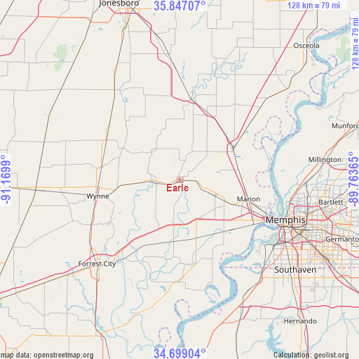
Earle GPS coordinates[2]
35° 16' 30.324" North, 90° 28' 0.372" West
| Map corner | latitude | longitude |
|---|---|---|
| Upper-left | 35.84707°, | -91.1699° |
| Center: | 35.27509°, | -90.46677° |
| Lower-right: | 34.69904°, | -89.76365° |
| Map W x H: | 127.6×127.6 km | = 79.3×79.3mi |
| max Lat: | 71.29058° ⇑73.8% North |
| Earle: | 35.27509° |
| min Lat: | ⇓26.2% South 19.06759° |
| min Long | Earle | max Long |
| -171.73463° | -90.46677° | -66.98998° |
| W 39.2%⇐ | ⇒60.8% E |
Elevation
Elevation of Earle is 62 m = 203 ft, and this is 232.8 m = 764 ft below average elevation for this country.
| Max E: |
3189 m = 10463 ft | 76.7% |
| Avg. | 294.8 m = 967 ft | |
| Earle | 62 m = 203 ft | |
Min E: |
-60 m = -197 ft | 23.3% |
See also: United States elevation on elevation.city.
Geographical zone
Earle is located in North temperate zone (between Tropic of Cancer and the Arctic Circle). Distance of this Northern Tropic circle is 1316.3 km =817.9 mi to South.| Distance of | km | miles | from Earle |
|---|---|---|---|
| North Pole | 6084.8 | 3780.9 | to North |
| Arctic Circle | 3479 | 2161.7 | to North |
| Tropic Cancer | 1316.3 | 817.9 | to South |
| Equator | 3922.2 | 2437.1 | to South |


Nearby cities:
15 places around Earle: (largest is in red/bold)
• Cherry Valley
29.6 km =18.4 mi,  298°
298°
• Forrest City
41.8 km =26 mi,  224°
224°
• Harrisburg
39.3 km =24.4 mi,  324°
324°
• Hughes
36.2 km =22.5 mi,  180°
180°
• Joiner
38.9 km =24.2 mi,  48°
48°
• Lepanto
39.4 km =24.5 mi,  18°
18°
• Madison
37.3 km =23.2 mi, 218°
• Marion
25.5 km =15.8 mi,  105°
105°
• Marked Tree
29 km =18 mi,  8°
8°
• Memphis
40.4 km =25.1 mi, 110°
• Parkin
9.6 km =6 mi,  262°
262°
• Turrell
22.2 km =13.8 mi,  58°
58°
• Tyronza
25.8 km =16 mi, 22°
• West Memphis
29.4 km =18.3 mi,  119°
119°
• Wynne
29.6 km =18.4 mi, 259°
Sources, notices
• [Note1] Compared only with cities in United States existing in our database
• [Src1] Map data: © OpenStreetMap contributors (CC-BY-SA)
• [Src2] Other city data from geonames.org with taken over terms of usage.
• [Src3] Geographical zone / Annual Mean Temperature by Robert A. Rohde @ Wikipedia
