Wynne geodata
Wynne (Arkansas) is a seat of a second-order administrative division; located in United States in America/Chicago (GMT-5) time zone. With population of 8,193 people, there are 5198 cities with bigger population in this country. Compared to other cities in United States, 74.1% of cities are located further ↑North; 61.6% of cities are located further →East and 73.2% of cities have higher elevation than Wynne. Note1


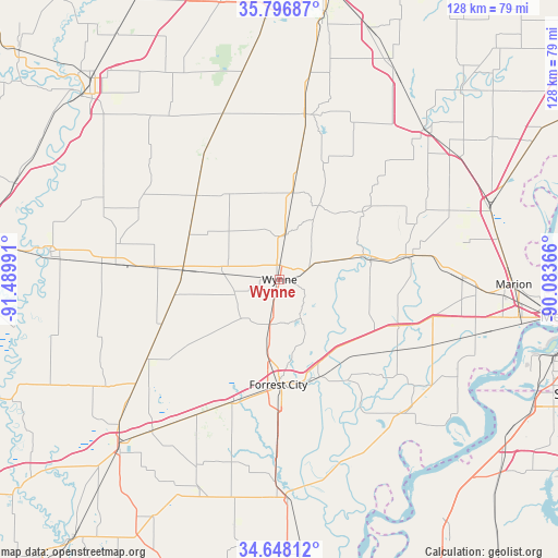
Wynne GPS coordinates[2]
35° 13' 28.308" North, 90° 47' 12.408" West
| Map corner | latitude | longitude |
|---|---|---|
| Upper-left | 35.79687°, | -91.48991° |
| Center: | 35.22453°, | -90.78678° |
| Lower-right: | 34.64812°, | -90.08366° |
| Map W x H: | 127.7×127.7 km | = 79.3×79.3mi |
| max Lat: | 71.29058° ⇑74.1% North |
| Wynne: | 35.22453° |
| min Lat: | ⇓25.9% South 19.06759° |
| min Long | Wynne | max Long |
| -171.73463° | -90.78678° | -66.98998° |
| W 38.4%⇐ | ⇒61.6% E |
Elevation
Elevation of Wynne is 82 m = 269 ft, and this is 212.8 m = 698 ft below average elevation for this country.
| Max E: |
3189 m = 10463 ft | 73.2% |
| Avg. | 294.8 m = 967 ft | |
| Wynne | 82 m = 269 ft | |
Min E: |
-60 m = -197 ft | 26.8% |
See also: United States elevation on elevation.city.
Geographical zone
Wynne is located in North temperate zone (between Tropic of Cancer and the Arctic Circle). Distance of this Northern Tropic circle is 1310.7 km =814.4 mi to South.| Distance of | km | miles | from Wynne |
|---|---|---|---|
| North Pole | 6090.5 | 3784.5 | to North |
| Arctic Circle | 3484.6 | 2165.2 | to North |
| Tropic Cancer | 1310.7 | 814.4 | to South |
| Equator | 3916.6 | 2433.7 | to South |


Nearby cities:
15 places around Wynne: (largest is in red/bold)
• Cherry Valley
20 km =12.4 mi,  8°
8°
• Cotton Plant
48.6 km =30.2 mi,  240°
240°
• Earle
29.6 km =18.4 mi,  79°
79°
• Forrest City
24.1 km =15 mi,  180°
180°
• Harrisburg
38.3 km =23.8 mi, 9°
• Hughes
41.9 km =26 mi,  136°
136°
• Madison
24.2 km =15 mi,  166°
166°
• Marianna
50.2 km =31.2 mi, 176°
• Marked Tree
47.7 km =29.6 mi,  44°
44°
• McCrory
37.7 km =23.4 mi,  275°
275°
• Palestine
30 km =18.6 mi,  200°
200°
• Parkin
20 km =12.4 mi, 77°
• Turrell
51 km =31.7 mi,  70°
70°
• Tyronza
48.8 km =30.3 mi,  52°
52°
• Weiner
45.2 km =28.1 mi,  347°
347°
Sources, notices
• [Note1] Compared only with cities in United States existing in our database
• [Src1] Map data: © OpenStreetMap contributors (CC-BY-SA)
• [Src2] Other city data from geonames.org with taken over terms of usage.
• [Src3] Geographical zone / Annual Mean Temperature by Robert A. Rohde @ Wikipedia
