Crawfordville geodata
Crawfordville (Florida) is a seat of a second-order administrative division; located in United States in America/New_York (GMT-4) time zone. With population of 3,702 people, there are 8587 cities with bigger population in this country. Compared to other cities in United States, 92.9% of cities are located further ↑North; 57.9% of cities are located further ←West and 90% of cities have higher elevation than Crawfordville. Note1


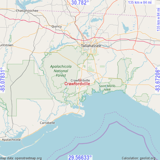
Crawfordville GPS coordinates[2]
30° 10' 33.744" North, 84° 22' 30.648" West
| Map corner | latitude | longitude |
|---|---|---|
| Upper-left | 30.782°, | -85.07831° |
| Center: | 30.17604°, | -84.37518° |
| Lower-right: | 29.56633°, | -83.67206° |
| Map W x H: | 135.2×135.2 km | = 84×84mi |
| max Lat: | 71.29058° ⇑92.9% North |
| Crawfordville: | 30.17604° |
| min Lat: | ⇓7.1% South 19.06759° |
| min Long | Crawfordville | max Long |
| -171.73463° | -84.37518° | -66.98998° |
| W 57.9%⇐ | ⇒42.1% E |
Elevation
Elevation of Crawfordville is 16 m = 52 ft, and this is 278.8 m = 915 ft below average elevation for this country.
| Max E: |
3189 m = 10463 ft | 90% |
| Avg. | 294.8 m = 967 ft | |
| Crawfordville | 16 m = 52 ft | |
Min E: |
-60 m = -197 ft | 10% |
See also: United States elevation on elevation.city.
Geographical zone
Crawfordville is located in North temperate zone (between Tropic of Cancer and the Arctic Circle). Distance of this Northern Tropic circle is 749.3 km =465.6 mi to South.| Distance of | km | miles | from Crawfordville |
|---|---|---|---|
| North Pole | 6651.8 | 4133.2 | to North |
| Arctic Circle | 4045.9 | 2514 | to North |
| Tropic Cancer | 749.3 | 465.6 | to South |
| Equator | 3355.3 | 2084.9 | to South |


Nearby cities:
15 places around Crawfordville: (largest is in red/bold)
• Blountstown
71.1 km =44.2 mi,  294°
294°
• Bristol
64.4 km =40 mi,  296°
296°
• Carrabelle
45.4 km =28.2 mi,  217°
217°
• Chattahoochee
74.2 km =46.1 mi,  322°
322°
• Eastpoint
68.8 km =42.8 mi, 224°
• Greensboro
56.4 km =35 mi, 320°
• Gretna
56.1 km =34.9 mi,  330°
330°
• Havana
49.9 km =31 mi,  355°
355°
• Hosford
47 km =29.2 mi, 299°
• Midway
36.3 km =22.6 mi,  347°
347°
• Monticello
63.4 km =39.4 mi,  49°
49°
• Panacea
15.5 km =9.6 mi,  184°
184°
• Quincy
49.9 km =31 mi,  336°
336°
• Tallahassee
30.5 km =19 mi,  17°
17°
• Woodville
19.7 km =12.2 mi,  38°
38°
Sources, notices
• [Note1] Compared only with cities in United States existing in our database
• [Src1] Map data: © OpenStreetMap contributors (CC-BY-SA)
• [Src2] Other city data from geonames.org with taken over terms of usage.
• [Src3] Geographical zone / Annual Mean Temperature by Robert A. Rohde @ Wikipedia
