Apopka geodata
Apopka (Florida) is a populated place; located in United States in America/New_York (GMT-4) time zone. With population of 48,382 people, there are 993 cities with bigger population in this country. Compared to other cities in United States, 95.7% of cities are located further ↑North; 67.6% of cities are located further ←West and 79.5% of cities have higher elevation than Apopka. Note1


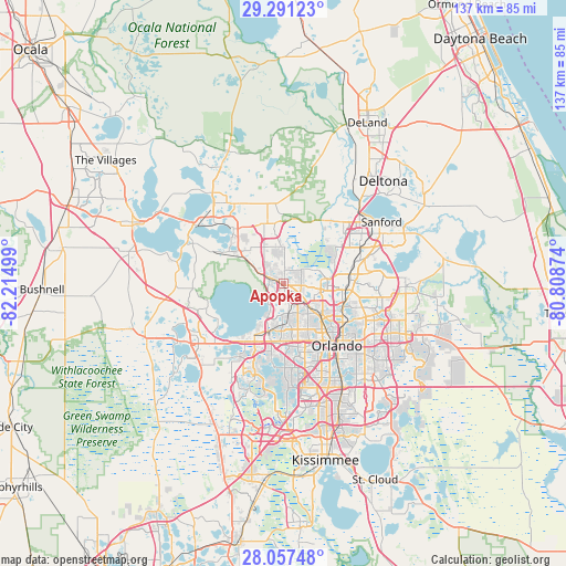
Apopka GPS coordinates[2]
28° 40' 34.212" North, 81° 30' 42.696" West
| Map corner | latitude | longitude |
|---|---|---|
| Upper-left | 29.29123°, | -82.21499° |
| Center: | 28.67617°, | -81.51186° |
| Lower-right: | 28.05748°, | -80.80874° |
| Map W x H: | 137.2×137.2 km | = 85.3×85.3mi |
| max Lat: | 71.29058° ⇑95.7% North |
| Apopka: | 28.67617° |
| min Lat: | ⇓4.3% South 19.06759° |
| min Long | Apopka | max Long |
| -171.73463° | -81.51186° | -66.98998° |
| W 67.6%⇐ | ⇒32.4% E |
Elevation
Elevation of Apopka is 49 m = 161 ft, and this is 245.8 m = 806 ft below average elevation for this country.
| Max E: |
3189 m = 10463 ft | 79.5% |
| Avg. | 294.8 m = 967 ft | |
| Apopka | 49 m = 161 ft | |
Min E: |
-60 m = -197 ft | 20.5% |
See also: Apopka elevation on elevation.city.
Geographical zone
Apopka is located in North temperate zone (between Tropic of Cancer and the Arctic Circle). Distance of this Northern Tropic circle is 582.6 km =362 mi to South.| Distance of | km | miles | from Apopka |
|---|---|---|---|
| North Pole | 6818.6 | 4236.9 | to North |
| Arctic Circle | 4212.7 | 2617.6 | to North |
| Tropic Cancer | 582.6 | 362 | to South |
| Equator | 3188.5 | 1981.2 | to South |


Nearby cities:
15 places around Apopka: (largest is in red/bold)
• Altamonte Springs
14.4 km =8.9 mi,  96°
96°
• Clarcona
7.2 km =4.5 mi,  169°
169°
• Eatonville
14.5 km =9 mi,  118°
118°
• Fairview Shores
14.9 km =9.3 mi,  129°
129°
• Forest City
6.8 km =4.2 mi, 98°
• Lockhart
9.2 km =5.7 mi, 133°
• Mount Plymouth
14.8 km =9.2 mi,  351°
351°
• Ocoee
12.3 km =7.6 mi,  194°
194°
• Paradise Heights
6.6 km =4.1 mi,  208°
208°
• Pine Hills
14.3 km =8.9 mi,  156°
156°
• South Apopka
1.6 km =1 mi, 171°
• Tangerine
15.2 km =9.4 mi,  310°
310°
• Wekiwa Springs
8.8 km =5.5 mi,  73°
73°
• Winter Garden
14.3 km =8.9 mi, 210°
• Zellwood
10.6 km =6.6 mi, 305°
Sources, notices
• [Note1] Compared only with cities in United States existing in our database
• [Src1] Map data: © OpenStreetMap contributors (CC-BY-SA)
• [Src2] Other city data from geonames.org with taken over terms of usage.
• [Src3] Geographical zone / Annual Mean Temperature by Robert A. Rohde @ Wikipedia
