Brandon geodata
Brandon (Florida) is a populated place; located in United States in America/New_York (GMT-4) time zone. With population of 103,483 people, there are 336 cities with bigger population in this country. Compared to other cities in United States, 96.8% of cities are located further ↑North; 64.7% of cities are located further ←West and 88.2% of cities have higher elevation than Brandon. Note1


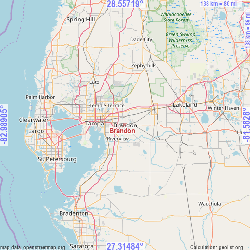
Brandon GPS coordinates[2]
27° 56' 16.08" North, 82° 17' 9.312" West
| Map corner | latitude | longitude |
|---|---|---|
| Upper-left | 28.55719°, | -82.98905° |
| Center: | 27.9378°, | -82.28592° |
| Lower-right: | 27.31484°, | -81.5828° |
| Map W x H: | 138.1×138.1 km | = 85.8×85.8mi |
| max Lat: | 71.29058° ⇑96.8% North |
| Brandon: | 27.9378° |
| min Lat: | ⇓3.2% South 19.06759° |
| min Long | Brandon | max Long |
| -171.73463° | -82.28592° | -66.98998° |
| W 64.7%⇐ | ⇒35.3% E |
Elevation
Elevation of Brandon is 20 m = 66 ft, and this is 274.8 m = 902 ft below average elevation for this country.
| Max E: |
3189 m = 10463 ft | 88.2% |
| Avg. | 294.8 m = 967 ft | |
| Brandon | 20 m = 66 ft | |
Min E: |
-60 m = -197 ft | 11.8% |
See also: Brandon elevation on elevation.city.
Geographical zone
Brandon is located in North temperate zone (between Tropic of Cancer and the Arctic Circle). Distance of this Northern Tropic circle is 500.5 km =311 mi to South.| Distance of | km | miles | from Brandon |
|---|---|---|---|
| North Pole | 6900.7 | 4287.9 | to North |
| Arctic Circle | 4294.8 | 2668.7 | to North |
| Tropic Cancer | 500.5 | 311 | to South |
| Equator | 3106.4 | 1930.2 | to South |


Nearby cities:
15 places around Brandon: (largest is in red/bold)
• Bloomingdale
6.6 km =4.1 mi,  137°
137°
• Boyette
14.8 km =9.2 mi,  155°
155°
• Dover
9 km =5.6 mi,  46°
46°
• East Lake-Orient Park
10.4 km =6.5 mi,  298°
298°
• Fish Hawk
12.2 km =7.6 mi, 142°
• Gibsonton
13.3 km =8.3 mi,  225°
225°
• Mango
5.1 km =3.2 mi,  336°
336°
• Palm River-Clair Mel
9.3 km =5.8 mi,  260°
260°
• Progress Village
8.8 km =5.5 mi,  241°
241°
• Riverview
8.9 km =5.5 mi,  206°
206°
• Seffner
5.2 km =3.2 mi,  11°
11°
• Tampa
17 km =10.6 mi,  273°
273°
• Temple Terrace
14.8 km =9.2 mi,  316°
316°
• Thonotosassa
13.8 km =8.6 mi,  353°
353°
• Valrico
4.9 km =3 mi,  89°
89°
Sources, notices
• [Note1] Compared only with cities in United States existing in our database
• [Src1] Map data: © OpenStreetMap contributors (CC-BY-SA)
• [Src2] Other city data from geonames.org with taken over terms of usage.
• [Src3] Geographical zone / Annual Mean Temperature by Robert A. Rohde @ Wikipedia
