East Lake-Orient Park geodata
East Lake-Orient Park (Florida) is a populated place; located in United States in America/New_York (GMT-4) time zone. With population of 22,753 people, there are 2225 cities with bigger population in this country. Compared to other cities in United States, 96.7% of cities are located further ↑North; 64.4% of cities are located further ←West and 90% of cities have higher elevation than East Lake-Orient Park. Note1
Current local time in East Lake-Orient Park:
02:46 AM, WednesdayDifference from your time zone: hours


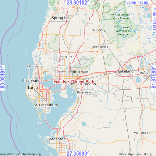
East Lake-Orient Park GPS coordinates[2]
27° 58' 57.684" North, 82° 22' 43.608" West
| Map corner | latitude | longitude |
|---|---|---|
| Upper-left | 28.60182°, | -83.08191° |
| Center: | 27.98269°, | -82.37878° |
| Lower-right: | 27.35999°, | -81.67566° |
| Map W x H: | 138.1×138.1 km | = 85.8×85.8mi |
| max Lat: | 71.29058° ⇑96.7% North |
| East Lake-Orient Park: | 27.98269° |
| min Lat: | ⇓3.3% South 19.06759° |
| min Long | East Lake-Orien | max Long |
| -171.73463° | -82.37878° | -66.98998° |
| W 64.4%⇐ | ⇒35.6% E |
Elevation
Elevation of East Lake-Orient Park is 16 m = 52 ft, and this is 278.8 m = 915 ft below average elevation for this country.
| Max E: |
3189 m = 10463 ft | 90% |
| Avg. | 294.8 m = 967 ft | |
| East Lake-Orient Park | 16 m = 52 ft | |
Min E: |
-60 m = -197 ft | 10% |
See also: United States elevation on elevation.city.
Geographical zone
East Lake-Orient Park is located in North temperate zone (between Tropic of Cancer and the Arctic Circle). Distance of this Northern Tropic circle is 505.5 km =314.1 mi to South.| Distance of | km | miles | from East Lake-Orient Park |
|---|---|---|---|
| North Pole | 6895.7 | 4284.8 | to North |
| Arctic Circle | 4289.8 | 2665.6 | to North |
| Tropic Cancer | 505.5 | 314.1 | to South |
| Equator | 3111.4 | 1933.3 | to South |


Nearby cities:
15 places around East Lake-Orient Park: (largest is in red/bold)
• Brandon
10.4 km =6.5 mi,  118°
118°
• Carrollwood
13.5 km =8.4 mi,  303°
303°
• Egypt Lake-Leto
13.1 km =8.1 mi,  287°
287°
• Gibsonton
14.4 km =8.9 mi,  181°
181°
• Lake Magdalene
13.7 km =8.5 mi,  318°
318°
• Mango
7.1 km =4.4 mi,  92°
92°
• Palm River-Clair Mel
6.5 km =4 mi, 180°
• Progress Village
9.3 km =5.8 mi,  171°
171°
• Riverview
13.9 km =8.6 mi,  158°
158°
• Seffner
10.1 km =6.3 mi, 89°
• Tampa
8.7 km =5.4 mi,  243°
243°
• Temple Terrace
5.9 km =3.7 mi,  350°
350°
• Thonotosassa
11.5 km =7.1 mi,  40°
40°
• University
11.7 km =7.3 mi,  329°
329°
• Valrico
14.8 km =9.2 mi,  109°
109°
Sources, notices
• [Note1] Compared only with cities in United States existing in our database
• [Src1] Map data: © OpenStreetMap contributors (CC-BY-SA)
• [Src2] Other city data from geonames.org with taken over terms of usage.
• [Src3] Geographical zone / Annual Mean Temperature by Robert A. Rohde @ Wikipedia
