Tampa geodata
Tampa (Florida) is a seat of a second-order administrative division; located in United States in America/New_York (GMT-4) time zone. With population of 369,075 people, there are 59 cities with bigger population in this country. Compared to other cities in United States, 96.7% of cities are located further ↑North; 64% of cities are located further ←West and 81.3% of cities have higher elevation than Tampa. Note1


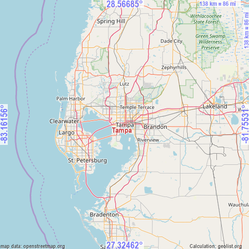
Tampa GPS coordinates[2]
27° 56' 51.072" North, 82° 27' 30.348" West
| Map corner | latitude | longitude |
|---|---|---|
| Upper-left | 28.56685°, | -83.16156° |
| Center: | 27.94752°, | -82.45843° |
| Lower-right: | 27.32462°, | -81.75531° |
| Map W x H: | 138.1×138.1 km | = 85.8×85.8mi |
| max Lat: | 71.29058° ⇑96.7% North |
| Tampa: | 27.94752° |
| min Lat: | ⇓3.3% South 19.06759° |
| min Long | Tampa | max Long |
| -171.73463° | -82.45843° | -66.98998° |
| W 64%⇐ | ⇒36% E |
Elevation
Elevation of Tampa is 41 m = 135 ft, and this is 253.8 m = 833 ft below average elevation for this country.
| Max E: |
3189 m = 10463 ft | 81.3% |
| Avg. | 294.8 m = 967 ft | |
| Tampa | 41 m = 135 ft | |
Min E: |
-60 m = -197 ft | 18.7% |
See also: Tampa elevation on elevation.city.
Geographical zone
Tampa is located in North temperate zone (between Tropic of Cancer and the Arctic Circle). Distance of this Northern Tropic circle is 501.6 km =311.7 mi to South.| Distance of | km | miles | from Tampa |
|---|---|---|---|
| North Pole | 6899.6 | 4287.2 | to North |
| Arctic Circle | 4293.7 | 2668 | to North |
| Tropic Cancer | 501.6 | 311.7 | to South |
| Equator | 3107.5 | 1930.9 | to South |


Nearby cities:
15 places around Tampa: (largest is in red/bold)
• Brandon
17 km =10.6 mi,  93°
93°
• Carrollwood
11.9 km =7.4 mi,  343°
343°
• Carrollwood Village
14.7 km =9.1 mi, 335°
• East Lake-Orient Park
8.7 km =5.4 mi,  63°
63°
• Egypt Lake-Leto
9.1 km =5.7 mi,  328°
328°
• Gibsonton
12.8 km =8 mi,  144°
144°
• Lake Magdalene
14.1 km =8.8 mi,  354°
354°
• Mango
15.3 km =9.5 mi,  76°
76°
• Northdale
16.9 km =10.5 mi, 344°
• Palm River-Clair Mel
8.2 km =5.1 mi,  108°
108°
• Progress Village
10.6 km =6.6 mi,  119°
119°
• Riverview
15.8 km =9.8 mi, 124°
• Temple Terrace
11.9 km =7.4 mi,  34°
34°
• Town 'n' Country
13.6 km =8.5 mi,  300°
300°
• University
14.2 km =8.8 mi,  7°
7°
Sources, notices
• [Note1] Compared only with cities in United States existing in our database
• [Src1] Map data: © OpenStreetMap contributors (CC-BY-SA)
• [Src2] Other city data from geonames.org with taken over terms of usage.
• [Src3] Geographical zone / Annual Mean Temperature by Robert A. Rohde @ Wikipedia
