Valrico geodata
Valrico (Florida) is a populated place; located in United States in America/New_York (GMT-4) time zone. With population of 35,545 people, there are 1385 cities with bigger population in this country. Compared to other cities in United States, 96.7% of cities are located further ↑North; 64.8% of cities are located further ←West and 87.4% of cities have higher elevation than Valrico. Note1


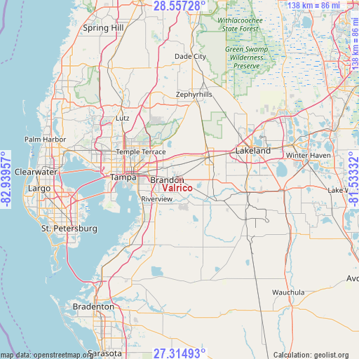
Valrico GPS coordinates[2]
27° 56' 16.404" North, 82° 14' 11.184" West
| Map corner | latitude | longitude |
|---|---|---|
| Upper-left | 28.55728°, | -82.93957° |
| Center: | 27.93789°, | -82.23644° |
| Lower-right: | 27.31493°, | -81.53332° |
| Map W x H: | 138.1×138.1 km | = 85.8×85.8mi |
| max Lat: | 71.29058° ⇑96.7% North |
| Valrico: | 27.93789° |
| min Lat: | ⇓3.3% South 19.06759° |
| min Long | Valrico | max Long |
| -171.73463° | -82.23644° | -66.98998° |
| W 64.8%⇐ | ⇒35.2% E |
Elevation
Elevation of Valrico is 22 m = 72 ft, and this is 272.8 m = 895 ft below average elevation for this country.
| Max E: |
3189 m = 10463 ft | 87.4% |
| Avg. | 294.8 m = 967 ft | |
| Valrico | 22 m = 72 ft | |
Min E: |
-60 m = -197 ft | 12.6% |
See also: United States elevation on elevation.city.
Geographical zone
Valrico is located in North temperate zone (between Tropic of Cancer and the Arctic Circle). Distance of this Northern Tropic circle is 500.5 km =311 mi to South.| Distance of | km | miles | from Valrico |
|---|---|---|---|
| North Pole | 6900.7 | 4287.9 | to North |
| Arctic Circle | 4294.8 | 2668.7 | to North |
| Tropic Cancer | 500.5 | 311 | to South |
| Equator | 3106.4 | 1930.2 | to South |


Nearby cities:
15 places around Valrico: (largest is in red/bold)
• Bloomingdale
4.9 km =3 mi,  184°
184°
• Boyette
13.5 km =8.4 mi,  174°
174°
• Brandon
4.9 km =3 mi,  269°
269°
• Dover
6.5 km =4 mi,  14°
14°
• East Lake-Orient Park
14.8 km =9.2 mi,  289°
289°
• Fish Hawk
10 km =6.2 mi, 165°
• Gibsonton
17.1 km =10.6 mi,  236°
236°
• Mango
8.3 km =5.2 mi,  304°
304°
• Palm River-Clair Mel
14.1 km =8.8 mi,  263°
263°
• Plant City
15 km =9.3 mi,  53°
53°
• Progress Village
13.3 km =8.3 mi,  251°
251°
• Riverview
11.9 km =7.4 mi,  227°
227°
• Seffner
6.4 km =4 mi,  322°
322°
• Temple Terrace
18.5 km =11.5 mi,  305°
305°
• Thonotosassa
15.2 km =9.4 mi,  334°
334°
Sources, notices
• [Note1] Compared only with cities in United States existing in our database
• [Src1] Map data: © OpenStreetMap contributors (CC-BY-SA)
• [Src2] Other city data from geonames.org with taken over terms of usage.
• [Src3] Geographical zone / Annual Mean Temperature by Robert A. Rohde @ Wikipedia
