Egypt Lake-Leto geodata
Egypt Lake-Leto (Florida) is a populated place; located in United States in America/New_York (GMT-4) time zone. With population of 35,282 people, there are 1395 cities with bigger population in this country. Compared to other cities in United States, 96.6% of cities are located further ↑North; 63.8% of cities are located further ←West and 91.5% of cities have higher elevation than Egypt Lake-Leto. Note1


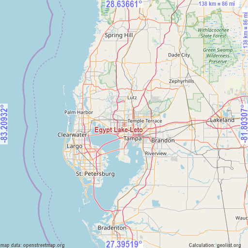
Egypt Lake-Leto GPS coordinates[2]
28° 1' 3.684" North, 82° 30' 22.284" West
| Map corner | latitude | longitude |
|---|---|---|
| Upper-left | 28.63661°, | -83.20932° |
| Center: | 28.01769°, | -82.50619° |
| Lower-right: | 27.39519°, | -81.80307° |
| Map W x H: | 138×138 km | = 85.7×85.7mi |
| max Lat: | 71.29058° ⇑96.6% North |
| Egypt Lake-Leto: | 28.01769° |
| min Lat: | ⇓3.4% South 19.06759° |
| min Long | Egypt Lake-Leto | max Long |
| -171.73463° | -82.50619° | -66.98998° |
| W 63.8%⇐ | ⇒36.2% E |
Elevation
Elevation of Egypt Lake-Leto is 13 m = 43 ft, and this is 281.8 m = 925 ft below average elevation for this country.
| Max E: |
3189 m = 10463 ft | 91.5% |
| Avg. | 294.8 m = 967 ft | |
| Egypt Lake-Leto | 13 m = 43 ft | |
Min E: |
-60 m = -197 ft | 8.5% |
See also: United States elevation on elevation.city.
Geographical zone
Egypt Lake-Leto is located in North temperate zone (between Tropic of Cancer and the Arctic Circle). Distance of this Northern Tropic circle is 509.4 km =316.5 mi to South.| Distance of | km | miles | from Egypt Lake-Leto |
|---|---|---|---|
| North Pole | 6891.8 | 4282.4 | to North |
| Arctic Circle | 4285.9 | 2663.1 | to North |
| Tropic Cancer | 509.4 | 316.5 | to South |
| Equator | 3115.3 | 1935.8 | to South |


Nearby cities:
15 places around Egypt Lake-Leto: (largest is in red/bold)
• Carrollwood
3.8 km =2.4 mi,  19°
19°
• Carrollwood Village
5.7 km =3.5 mi,  345°
345°
• Cheval
14.6 km =9.1 mi,  356°
356°
• Citrus Park
9.2 km =5.7 mi,  317°
317°
• East Lake-Orient Park
13.1 km =8.1 mi,  107°
107°
• Greater Northdale
9.9 km =6.2 mi, 348°
• Lake Magdalene
7.1 km =4.4 mi,  28°
28°
• Lutz
15.5 km =9.6 mi, 16°
• Northdale
8.5 km =5.3 mi,  0°
0°
• Oldsmar
15.7 km =9.8 mi,  276°
276°
• Tampa
9.1 km =5.7 mi,  148°
148°
• Temple Terrace
11.6 km =7.2 mi,  80°
80°
• Town 'n' Country
7 km =4.3 mi,  263°
263°
• University
9.1 km =5.7 mi,  46°
46°
• Westchase
11 km =6.8 mi,  292°
292°
Sources, notices
• [Note1] Compared only with cities in United States existing in our database
• [Src1] Map data: © OpenStreetMap contributors (CC-BY-SA)
• [Src2] Other city data from geonames.org with taken over terms of usage.
• [Src3] Geographical zone / Annual Mean Temperature by Robert A. Rohde @ Wikipedia
