University geodata
University (Florida) is a populated place; located in United States in America/New_York (GMT-4) time zone. With population of 41,163 people, there are 1166 cities with bigger population in this country. Compared to other cities in United States, 96.5% of cities are located further ↑North; 64.1% of cities are located further ←West and 88.2% of cities have higher elevation than University. Note1


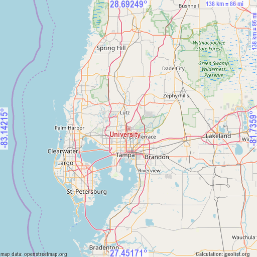
University GPS coordinates[2]
28° 4' 26.004" North, 82° 26' 20.472" West
| Map corner | latitude | longitude |
|---|---|---|
| Upper-left | 28.69249°, | -83.14215° |
| Center: | 28.07389°, | -82.43902° |
| Lower-right: | 27.45171°, | -81.7359° |
| Map W x H: | 138×138 km | = 85.7×85.7mi |
| max Lat: | 71.29058° ⇑96.5% North |
| University: | 28.07389° |
| min Lat: | ⇓3.5% South 19.06759° |
| min Long | University | max Long |
| -171.73463° | -82.43902° | -66.98998° |
| W 64.1%⇐ | ⇒35.9% E |
Elevation
Elevation of University is 20 m = 66 ft, and this is 274.8 m = 902 ft below average elevation for this country.
| Max E: |
3189 m = 10463 ft | 88.2% |
| Avg. | 294.8 m = 967 ft | |
| University | 20 m = 66 ft | |
Min E: |
-60 m = -197 ft | 11.8% |
See also: University elevation on elevation.city.
Geographical zone
University is located in North temperate zone (between Tropic of Cancer and the Arctic Circle). Distance of this Northern Tropic circle is 515.6 km =320.4 mi to South.| Distance of | km | miles | from University |
|---|---|---|---|
| North Pole | 6885.5 | 4278.5 | to North |
| Arctic Circle | 4279.7 | 2659.3 | to North |
| Tropic Cancer | 515.6 | 320.4 | to South |
| Equator | 3121.5 | 1939.6 | to South |


Nearby cities:
15 places around University: (largest is in red/bold)
• Carrollwood
5.9 km =3.7 mi,  243°
243°
• Carrollwood Village
8.1 km =5 mi,  264°
264°
• Cheval
11.1 km =6.9 mi,  318°
318°
• Citrus Park
12.8 km =8 mi,  272°
272°
• East Lake-Orient Park
11.7 km =7.3 mi,  149°
149°
• Egypt Lake-Leto
9.1 km =5.7 mi,  226°
226°
• Greater Northdale
9.2 km =5.7 mi,  292°
292°
• Lake Magdalene
3.2 km =2 mi, 270°
• Lutz
8.9 km =5.5 mi,  345°
345°
• Northdale
6.9 km =4.3 mi, 288°
• Pebble Creek
12.3 km =7.6 mi,  47°
47°
• Tampa
14.2 km =8.8 mi,  187°
187°
• Temple Terrace
6.5 km =4 mi,  131°
131°
• Thonotosassa
13.5 km =8.4 mi,  95°
95°
• Town 'n' Country
15.3 km =9.5 mi, 242°
Sources, notices
• [Note1] Compared only with cities in United States existing in our database
• [Src1] Map data: © OpenStreetMap contributors (CC-BY-SA)
• [Src2] Other city data from geonames.org with taken over terms of usage.
• [Src3] Geographical zone / Annual Mean Temperature by Robert A. Rohde @ Wikipedia
