Navarre geodata
Navarre (Florida) is a populated place; located in United States in America/Chicago (GMT-5) time zone. With population of 31,378 people, there are 1583 cities with bigger population in this country. Compared to other cities in United States, 92.2% of cities are located further ↑North; 50.6% of cities are located further ←West and 97.4% of cities have higher elevation than Navarre. Note1


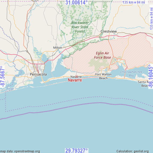
Navarre GPS coordinates[2]
30° 24' 5.724" North, 86° 51' 48.852" West
| Map corner | latitude | longitude |
|---|---|---|
| Upper-left | 31.00614°, | -87.5667° |
| Center: | 30.40159°, | -86.86357° |
| Lower-right: | 29.79327°, | -86.16045° |
| Map W x H: | 134.9×134.9 km | = 83.8×83.8mi |
| max Lat: | 71.29058° ⇑92.2% North |
| Navarre: | 30.40159° |
| min Lat: | ⇓7.8% South 19.06759° |
| min Long | Navarre | max Long |
| -171.73463° | -86.86357° | -66.98998° |
| W 50.6%⇐ | ⇒49.4% E |
Elevation
Elevation of Navarre is 6 m = 20 ft, and this is 288.8 m = 948 ft below average elevation for this country.
| Max E: |
3189 m = 10463 ft | 97.4% |
| Avg. | 294.8 m = 967 ft | |
| Navarre | 6 m = 20 ft | |
Min E: |
-60 m = -197 ft | 2.6% |
See also: United States elevation on elevation.city.
Geographical zone
Navarre is located in North temperate zone (between Tropic of Cancer and the Arctic Circle). Distance of this Northern Tropic circle is 774.4 km =481.2 mi to South.| Distance of | km | miles | from Navarre |
|---|---|---|---|
| North Pole | 6626.7 | 4117.6 | to North |
| Arctic Circle | 4020.8 | 2498.4 | to North |
| Tropic Cancer | 774.4 | 481.2 | to South |
| Equator | 3380.3 | 2100.4 | to South |


Nearby cities:
15 places around Navarre: (largest is in red/bold)
• Bagdad
27.2 km =16.9 mi,  323°
323°
• East Milton
28.2 km =17.5 mi,  327°
327°
• Fort Walton Beach
23.7 km =14.7 mi,  84°
84°
• Gulf Breeze
29.2 km =18.1 mi,  260°
260°
• Harold
28.7 km =17.8 mi,  356°
356°
• Holley
6.5 km =4 mi, 320°
• Lake Lorraine
28.9 km =18 mi, 81°
• Mary Esther
19.1 km =11.9 mi,  87°
87°
• Midway
13.6 km =8.5 mi,  272°
272°
• Ocean City
24.4 km =15.2 mi, 79°
• Oriole Beach
22.1 km =13.7 mi, 261°
• Shalimar
27.7 km =17.2 mi, 79°
• Tiger Point
18.6 km =11.6 mi, 262°
• Woodlawn Beach
12.3 km =7.6 mi, 263°
• Wright
22.4 km =13.9 mi,  74°
74°
Sources, notices
• [Note1] Compared only with cities in United States existing in our database
• [Src1] Map data: © OpenStreetMap contributors (CC-BY-SA)
• [Src2] Other city data from geonames.org with taken over terms of usage.
• [Src3] Geographical zone / Annual Mean Temperature by Robert A. Rohde @ Wikipedia
