Wright geodata
Wright (Florida) is a populated place; located in United States in America/Chicago (GMT-5) time zone. With population of 23,127 people, there are 2180 cities with bigger population in this country. Compared to other cities in United States, 91.9% of cities are located further ↑North; 51.2% of cities are located further ←West and 89.1% of cities have higher elevation than Wright. Note1


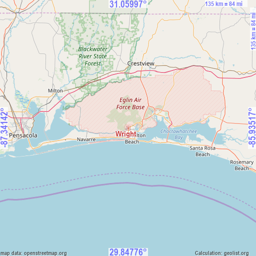
Wright GPS coordinates[2]
30° 27' 20.7" North, 86° 38' 17.844" West
| Map corner | latitude | longitude |
|---|---|---|
| Upper-left | 31.05997°, | -87.34142° |
| Center: | 30.45575°, | -86.63829° |
| Lower-right: | 29.84776°, | -85.93517° |
| Map W x H: | 134.8×134.8 km | = 83.8×83.8mi |
| max Lat: | 71.29058° ⇑91.9% North |
| Wright: | 30.45575° |
| min Lat: | ⇓8.1% South 19.06759° |
| min Long | Wright | max Long |
| -171.73463° | -86.63829° | -66.98998° |
| W 51.2%⇐ | ⇒48.8% E |
Elevation
Elevation of Wright is 18 m = 59 ft, and this is 276.8 m = 908 ft below average elevation for this country.
| Max E: |
3189 m = 10463 ft | 89.1% |
| Avg. | 294.8 m = 967 ft | |
| Wright | 18 m = 59 ft | |
Min E: |
-60 m = -197 ft | 10.9% |
See also: United States elevation on elevation.city.
Geographical zone
Wright is located in North temperate zone (between Tropic of Cancer and the Arctic Circle). Distance of this Northern Tropic circle is 780.4 km =484.9 mi to South.| Distance of | km | miles | from Wright |
|---|---|---|---|
| North Pole | 6620.7 | 4113.9 | to North |
| Arctic Circle | 4014.8 | 2494.7 | to North |
| Tropic Cancer | 780.4 | 484.9 | to South |
| Equator | 3386.4 | 2104.2 | to South |


Nearby cities:
15 places around Wright: (largest is in red/bold)
• Destin
15.3 km =9.5 mi,  116°
116°
• Eglin Air Force Base
8.4 km =5.2 mi,  87°
87°
• Eglin Village
9.5 km =5.9 mi, 85°
• Fort Walton Beach
4.4 km =2.7 mi,  152°
152°
• Harold
32.4 km =20.1 mi,  314°
314°
• Holley
25.8 km =16 mi,  267°
267°
• Lake Lorraine
7.2 km =4.5 mi,  102°
102°
• Mary Esther
5.7 km =3.5 mi,  206°
206°
• Miramar Beach
28.3 km =17.6 mi,  108°
108°
• Navarre
22.4 km =13.9 mi,  254°
254°
• Niceville
16.4 km =10.2 mi,  65°
65°
• Ocean City
2.9 km =1.8 mi, 124°
• Shalimar
5.8 km =3.6 mi, 101°
• Valparaiso
14.3 km =8.9 mi, 65°
• Woodlawn Beach
34.6 km =21.5 mi,  257°
257°
Sources, notices
• [Note1] Compared only with cities in United States existing in our database
• [Src1] Map data: © OpenStreetMap contributors (CC-BY-SA)
• [Src2] Other city data from geonames.org with taken over terms of usage.
• [Src3] Geographical zone / Annual Mean Temperature by Robert A. Rohde @ Wikipedia
