Hastings geodata
Hastings (Florida) is a populated place; located in United States in America/New_York (GMT-4) time zone. With population of 632 people, there are 19334 cities with bigger population in this country. Compared to other cities in United States, 94.1% of cities are located further ↑North; 67.6% of cities are located further ←West and 97.4% of cities have higher elevation than Hastings. Note1


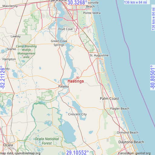
Hastings GPS coordinates[2]
29° 43' 4.872" North, 81° 30' 29.268" West
| Map corner | latitude | longitude |
|---|---|---|
| Upper-left | 30.3268°, | -82.21126° |
| Center: | 29.71802°, | -81.50813° |
| Lower-right: | 29.10552°, | -80.80501° |
| Map W x H: | 135.8×135.8 km | = 84.4×84.4mi |
| max Lat: | 71.29058° ⇑94.1% North |
| Hastings: | 29.71802° |
| min Lat: | ⇓5.9% South 19.06759° |
| min Long | Hastings | max Long |
| -171.73463° | -81.50813° | -66.98998° |
| W 67.6%⇐ | ⇒32.4% E |
Elevation
Elevation of Hastings is 6 m = 20 ft, and this is 288.8 m = 948 ft below average elevation for this country.
| Max E: |
3189 m = 10463 ft | 97.4% |
| Avg. | 294.8 m = 967 ft | |
| Hastings | 6 m = 20 ft | |
Min E: |
-60 m = -197 ft | 2.6% |
See also: United States elevation on elevation.city.
Geographical zone
Hastings is located in North temperate zone (between Tropic of Cancer and the Arctic Circle). Distance of this Northern Tropic circle is 698.4 km =434 mi to South.| Distance of | km | miles | from Hastings |
|---|---|---|---|
| North Pole | 6702.7 | 4164.9 | to North |
| Arctic Circle | 4096.8 | 2545.6 | to North |
| Tropic Cancer | 698.4 | 434 | to South |
| Equator | 3304.3 | 2053.2 | to South |


Nearby cities:
15 places around Hastings: (largest is in red/bold)
• Butler Beach
24.9 km =15.5 mi,  69°
69°
• Crescent Beach
25.2 km =15.7 mi,  77°
77°
• Crescent City
32 km =19.9 mi,  180°
180°
• East Palatka
11 km =6.8 mi,  232°
232°
• Flagler Estates
9.5 km =5.9 mi,  148°
148°
• Green Cove Springs
34.6 km =21.5 mi,  331°
331°
• Palatka
14.7 km =9.1 mi,  238°
238°
• Palm Coast
32.6 km =20.3 mi,  117°
117°
• Pomona Park
25.5 km =15.8 mi,  198°
198°
• Saint Augustine
27.1 km =16.8 mi,  43°
43°
• Saint Augustine Beach
27.7 km =17.2 mi,  57°
57°
• Saint Augustine Shores
21.7 km =13.5 mi, 61°
• Saint Augustine South
23.3 km =14.5 mi,  53°
53°
• Villano Beach
31.6 km =19.6 mi, 39°
• Welaka
30.9 km =19.2 mi,  210°
210°
Sources, notices
• [Note1] Compared only with cities in United States existing in our database
• [Src1] Map data: © OpenStreetMap contributors (CC-BY-SA)
• [Src2] Other city data from geonames.org with taken over terms of usage.
• [Src3] Geographical zone / Annual Mean Temperature by Robert A. Rohde @ Wikipedia
