Saint Augustine Beach geodata
Saint Augustine Beach (Florida) is a populated place; located in United States in America/New_York (GMT-4) time zone. With population of 6,176 people, there are 6286 cities with bigger population in this country. Compared to other cities in United States, 93.8% of cities are located further ↑North; 68.6% of cities are located further ←West and 99.6% of cities have higher elevation than Saint Augustine Beach. Note1


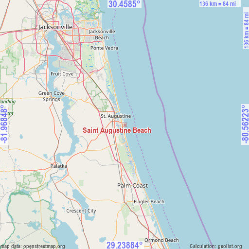
Saint Augustine Beach GPS coordinates[2]
29° 51' 1.908" North, 81° 15' 55.26" West
| Map corner | latitude | longitude |
|---|---|---|
| Upper-left | 30.4585°, | -81.96848° |
| Center: | 29.85053°, | -81.26535° |
| Lower-right: | 29.23884°, | -80.56223° |
| Map W x H: | 135.6×135.6 km | = 84.3×84.3mi |
| max Lat: | 71.29058° ⇑93.8% North |
| Saint Augustine Beach: | 29.85053° |
| min Lat: | ⇓6.2% South 19.06759° |
| min Long | Saint Augustine | max Long |
| -171.73463° | -81.26535° | -66.98998° |
| W 68.6%⇐ | ⇒31.4% E |
Elevation
Elevation of Saint Augustine Beach is 1 m = 3 ft, and this is 293.8 m = 964 ft below average elevation for this country.
| Max E: |
3189 m = 10463 ft | 99.6% |
| Avg. | 294.8 m = 967 ft | |
| Saint Augustine Beach | 1 m = 3 ft | |
Min E: |
-60 m = -197 ft | 0.4% |
See also: United States elevation on elevation.city.
Geographical zone
Saint Augustine Beach is located in North temperate zone (between Tropic of Cancer and the Arctic Circle). Distance of this Northern Tropic circle is 713.1 km =443.1 mi to South.| Distance of | km | miles | from Saint Augustine Beach |
|---|---|---|---|
| North Pole | 6688 | 4155.7 | to North |
| Arctic Circle | 4082.1 | 2536.5 | to North |
| Tropic Cancer | 713.1 | 443.1 | to South |
| Equator | 3319.1 | 2062.4 | to South |


Nearby cities:
15 places around Saint Augustine Beach: (largest is in red/bold)
• Butler Beach
5.8 km =3.6 mi,  181°
181°
• Crescent Beach
9.2 km =5.7 mi,  172°
172°
• East Palatka
38.6 km =24 mi,  236°
236°
• Flagler Estates
29.4 km =18.3 mi,  219°
219°
• Hastings
27.7 km =17.2 mi, 237°
• Nocatee
29.1 km =18.1 mi,  332°
332°
• Palatka
42.4 km =26.3 mi, 237°
• Palm Coast
30 km =18.6 mi, 169°
• Palm Valley
38.2 km =23.7 mi,  342°
342°
• Saint Augustine
6.8 km =4.2 mi,  316°
316°
• Saint Augustine Shores
6.2 km =3.9 mi, 224°
• Saint Augustine South
4.8 km =3 mi,  259°
259°
• Sawgrass
39.4 km =24.5 mi,  345°
345°
• St. Johns
37.4 km =23.2 mi,  313°
313°
• Villano Beach
10.4 km =6.5 mi, 340°
Sources, notices
• [Note1] Compared only with cities in United States existing in our database
• [Src1] Map data: © OpenStreetMap contributors (CC-BY-SA)
• [Src2] Other city data from geonames.org with taken over terms of usage.
• [Src3] Geographical zone / Annual Mean Temperature by Robert A. Rohde @ Wikipedia
