Saint Augustine Shores geodata
Saint Augustine Shores (Florida) is a populated place; located in United States in America/New_York (GMT-4) time zone. With population of 7,359 people, there are 5618 cities with bigger population in this country. Compared to other cities in United States, 93.9% of cities are located further ↑North; 68.5% of cities are located further ←West and 91.5% of cities have higher elevation than Saint Augustine Shores. Note1
Current local time in Saint Augustine Shores:
05:56 AM, TuesdayDifference from your time zone: hours


Saint Augustine Shores GPS coordinates[2]
29° 48' 38.88" North, 81° 18' 37.26" West
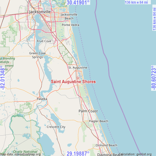
| Map corner | latitude | longitude |
|---|---|---|
| Upper-left | 30.41901°, | -82.01348° |
| Center: | 29.8108°, | -81.31035° |
| Lower-right: | 29.19887°, | -80.60723° |
| Map W x H: | 135.7×135.7 km | = 84.3×84.3mi |
| max Lat: | 71.29058° ⇑93.9% North |
| Saint Augustine Shores: | 29.8108° |
| min Lat: | ⇓6.1% South 19.06759° |
| min Long | Saint Augustine | max Long |
| -171.73463° | -81.31035° | -66.98998° |
| W 68.5%⇐ | ⇒31.5% E |
Elevation
Elevation of Saint Augustine Shores is 13 m = 43 ft, and this is 281.8 m = 925 ft below average elevation for this country.
| Max E: |
3189 m = 10463 ft | 91.5% |
| Avg. | 294.8 m = 967 ft | |
| Saint Augustine Shores | 13 m = 43 ft | |
Min E: |
-60 m = -197 ft | 8.5% |
See also: United States elevation on elevation.city.
Geographical zone
Saint Augustine Shores is located in North temperate zone (between Tropic of Cancer and the Arctic Circle). Distance of this Northern Tropic circle is 708.7 km =440.4 mi to South.| Distance of | km | miles | from Saint Augustine Shores |
|---|---|---|---|
| North Pole | 6692.4 | 4158.5 | to North |
| Arctic Circle | 4086.5 | 2539.2 | to North |
| Tropic Cancer | 708.7 | 440.4 | to South |
| Equator | 3314.7 | 2059.7 | to South |


Nearby cities:
15 places around Saint Augustine Shores: (largest is in red/bold)
• Bunnell
38.7 km =24 mi,  172°
172°
• Butler Beach
4.4 km =2.7 mi,  108°
108°
• Crescent Beach
7.2 km =4.5 mi,  130°
130°
• East Palatka
32.6 km =20.3 mi,  238°
238°
• Flagler Estates
23.2 km =14.4 mi,  217°
217°
• Green Cove Springs
40.8 km =25.4 mi,  299°
299°
• Hastings
21.7 km =13.5 mi, 241°
• Nocatee
31.6 km =19.6 mi,  343°
343°
• Palatka
36.4 km =22.6 mi, 240°
• Palm Coast
27 km =16.8 mi,  158°
158°
• Saint Augustine
9.3 km =5.8 mi,  357°
357°
• Saint Augustine Beach
6.2 km =3.9 mi,  44°
44°
• Saint Augustine South
3.5 km =2.2 mi,  353°
353°
• St. Johns
37.8 km =23.5 mi,  322°
322°
• Villano Beach
14.2 km =8.8 mi,  3°
3°
Sources, notices
• [Note1] Compared only with cities in United States existing in our database
• [Src1] Map data: © OpenStreetMap contributors (CC-BY-SA)
• [Src2] Other city data from geonames.org with taken over terms of usage.
• [Src3] Geographical zone / Annual Mean Temperature by Robert A. Rohde @ Wikipedia
