Butler Beach geodata
Butler Beach (Florida) is a populated place; located in United States in America/New_York (GMT-4) time zone. With population of 4,951 people, there are 7229 cities with bigger population in this country. Compared to other cities in United States, 93.9% of cities are located further ↑North; 68.6% of cities are located further ←West and 98.1% of cities have higher elevation than Butler Beach. Note1


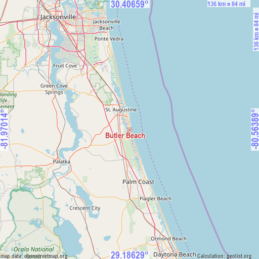
Butler Beach GPS coordinates[2]
29° 47' 53.88" North, 81° 16' 1.236" West
| Map corner | latitude | longitude |
|---|---|---|
| Upper-left | 30.40659°, | -81.97014° |
| Center: | 29.7983°, | -81.26701° |
| Lower-right: | 29.18629°, | -80.56389° |
| Map W x H: | 135.7×135.7 km | = 84.3×84.3mi |
| max Lat: | 71.29058° ⇑93.9% North |
| Butler Beach: | 29.7983° |
| min Lat: | ⇓6.1% South 19.06759° |
| min Long | Butler Beach | max Long |
| -171.73463° | -81.26701° | -66.98998° |
| W 68.6%⇐ | ⇒31.4% E |
Elevation
Elevation of Butler Beach is 5 m = 16 ft, and this is 289.8 m = 951 ft below average elevation for this country.
| Max E: |
3189 m = 10463 ft | 98.1% |
| Avg. | 294.8 m = 967 ft | |
| Butler Beach | 5 m = 16 ft | |
Min E: |
-60 m = -197 ft | 1.9% |
See also: United States elevation on elevation.city.
Geographical zone
Butler Beach is located in North temperate zone (between Tropic of Cancer and the Arctic Circle). Distance of this Northern Tropic circle is 707.3 km =439.5 mi to South.| Distance of | km | miles | from Butler Beach |
|---|---|---|---|
| North Pole | 6693.8 | 4159.3 | to North |
| Arctic Circle | 4087.9 | 2540.1 | to North |
| Tropic Cancer | 707.3 | 439.5 | to South |
| Equator | 3313.3 | 2058.8 | to South |


Nearby cities:
15 places around Butler Beach: (largest is in red/bold)
• Bunnell
36.9 km =22.9 mi,  178°
178°
• Crescent Beach
3.5 km =2.2 mi,  158°
158°
• East Palatka
35.6 km =22.1 mi,  244°
244°
• Flagler Beach
38.4 km =23.9 mi, 159°
• Flagler Estates
25 km =15.5 mi,  227°
227°
• Hastings
24.9 km =15.5 mi,  249°
249°
• Nocatee
34.3 km =21.3 mi,  337°
337°
• Palatka
39.5 km =24.5 mi, 245°
• Palm Coast
24.4 km =15.2 mi,  166°
166°
• Saint Augustine
11.7 km =7.3 mi, 336°
• Saint Augustine Beach
5.8 km =3.6 mi,  1°
1°
• Saint Augustine Shores
4.4 km =2.7 mi,  288°
288°
• Saint Augustine South
6.7 km =4.2 mi,  317°
317°
• St. Johns
41.5 km =25.8 mi, 319°
• Villano Beach
16 km =9.9 mi,  347°
347°
Sources, notices
• [Note1] Compared only with cities in United States existing in our database
• [Src1] Map data: © OpenStreetMap contributors (CC-BY-SA)
• [Src2] Other city data from geonames.org with taken over terms of usage.
• [Src3] Geographical zone / Annual Mean Temperature by Robert A. Rohde @ Wikipedia
