Holly Hill geodata
Holly Hill (Florida) is a populated place; located in United States in America/New_York (GMT-4) time zone. With population of 11,943 people, there are 3916 cities with bigger population in this country. Compared to other cities in United States, 95% of cities are located further ↑North; 69.4% of cities are located further ←West and 92.1% of cities have higher elevation than Holly Hill. Note1


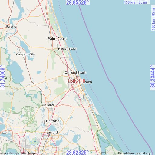
Holly Hill GPS coordinates[2]
29° 14' 36.924" North, 81° 2' 15.216" West
| Map corner | latitude | longitude |
|---|---|---|
| Upper-left | 29.85526°, | -81.74069° |
| Center: | 29.24359°, | -81.03756° |
| Lower-right: | 28.62825°, | -80.33444° |
| Map W x H: | 136.4×136.4 km | = 84.8×84.8mi |
| max Lat: | 71.29058° ⇑95% North |
| Holly Hill: | 29.24359° |
| min Lat: | ⇓5% South 19.06759° |
| min Long | Holly Hill | max Long |
| -171.73463° | -81.03756° | -66.98998° |
| W 69.4%⇐ | ⇒30.6% E |
Elevation
Elevation of Holly Hill is 12 m = 39 ft, and this is 282.8 m = 928 ft below average elevation for this country.
| Max E: |
3189 m = 10463 ft | 92.1% |
| Avg. | 294.8 m = 967 ft | |
| Holly Hill | 12 m = 39 ft | |
Min E: |
-60 m = -197 ft | 7.9% |
See also: United States elevation on elevation.city.
Geographical zone
Holly Hill is located in North temperate zone (between Tropic of Cancer and the Arctic Circle). Distance of this Northern Tropic circle is 645.7 km =401.2 mi to South.| Distance of | km | miles | from Holly Hill |
|---|---|---|---|
| North Pole | 6755.5 | 4197.7 | to North |
| Arctic Circle | 4149.6 | 2578.4 | to North |
| Tropic Cancer | 645.7 | 401.2 | to South |
| Equator | 3251.6 | 2020.4 | to South |


Nearby cities:
15 places around Holly Hill: (largest is in red/bold)
• Bunnell
32.7 km =20.3 mi,  319°
319°
• Daytona Beach
3.9 km =2.4 mi,  158°
158°
• Daytona Beach Shores
9.2 km =5.7 mi,  144°
144°
• De Leon Springs
33.6 km =20.9 mi,  245°
245°
• Edgewater
31.2 km =19.4 mi, 155°
• Flagler Beach
27.1 km =16.8 mi,  341°
341°
• Glencoe
25 km =15.5 mi,  165°
165°
• New Smyrna Beach
26.5 km =16.5 mi, 156°
• North DeLand
33.3 km =20.7 mi,  229°
229°
• Ormond Beach
5 km =3.1 mi, 339°
• Ormond-by-the-Sea
12.1 km =7.5 mi,  346°
346°
• Ponce Inlet
19.1 km =11.9 mi,  149°
149°
• Port Orange
12.4 km =7.7 mi, 160°
• Samsula-Spruce Creek
21.7 km =13.5 mi,  186°
186°
• South Daytona
9.2 km =5.7 mi, 159°
Sources, notices
• [Note1] Compared only with cities in United States existing in our database
• [Src1] Map data: © OpenStreetMap contributors (CC-BY-SA)
• [Src2] Other city data from geonames.org with taken over terms of usage.
• [Src3] Geographical zone / Annual Mean Temperature by Robert A. Rohde @ Wikipedia
